
Republic Of The Marshall Islands - Orubebbu, Ebijlerikku and Ebeye, looking north from Kwajalein.
Sent by Cindy from Army Post Office (APO) in Kwajalein in Marshall Islands.
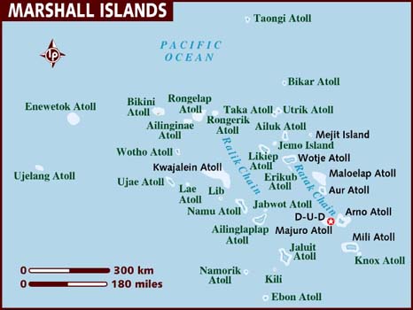
This is from Wikipedia : Kwajalein Atoll (pronounced /ˈkwɑːdʒɨlɨn/ in English; Marshallese: Kuwajleen, pronounced [kʷuwːɔɛt̪ʲl̪ʲɪn̪ʲ]), is part of the Republic of the Marshall Islands (RMI). The southernmost and largest island in the atoll is named Kwajalein Island, nicknamed Kwaj (/ˈkwɑːdʒ/) by English-speaking residents of the U.S. facilities.
The atoll lies in the Ralik Chain, 2,100 nautical miles (3900 km) southwest of Honolulu, Hawaii, at 8°43′N 167°44′E / 8.717°N 167.733°E / 8.717; 167.733.
Kwajalein is one of the world's largest coral atolls as measured by area of enclosed water. Comprising 97 islands and islets, it has a land area of 16.4 km² (6.33 mi²), and surrounds one of the largest lagoons in the world, with an area of 2174 km² (839 mi²).
Kwajalein Island is the southernmost, and the largest, of the islands in the Kwajalein atoll. The northernmost, and second largest, island is Roi-Namur.
The population of Kwajalein islet is currently below 1,000 individuals, mostly Americans and a small number of Marshall Islanders and other nationals, all of whom have express permission from the U.S. Army to live there. Approximately 13,500 Marshallese citizens live on the atoll, most on Ebeye Island.
The primary mode of personal transportation is the bicycle and housing is free for most personnel, depending on contract or tour of duty.


No comments:
Post a Comment