This is a project of collecting postcards from all over the world.
Tuesday, May 31, 2011
Canary Islands - Mapcard of Gran Canaria
Isla de Gran Canaria.
Sent by Desiree, a postcrosser from Holland.
This is from Wikipedia : Gran Canaria (Spanish pronunciation: [ɡɾaŋ kaˈna.ɾja]; originally meaning 'Great [Island] of Dogs') is the most populous island of the Canary Islands, with population of 829 597 (2008) which constitutes approximately 40% of the population of the archipelago. Also, it is second most populous island in Spain after Majorca. Located on the Atlantic Ocean about 150 kilometers (~93 miles) off the northwestern coast of Africa and about 1350 km (~838 miles) from Europe.
The capital of the island, Las Palmas de Gran Canaria, is also the largest city and capital autonomous community of the Canary Islands.
Gran Canaria was populated by the Canarii (Guanches), who may have arrived as early as 500 BC. The Canarii called the island Tamarán or Land of the Brave. After over a century of European (French, Portuguese...) incursions and attempts at conquest, the island was conquered on April 29, 1483, after a campaign that lasted 5 years, by the Kingdom of Castile, with the support of Queen Isabella I, a conquest which turned out to be an important step towards the expansion of the unified Spain.
The capital city of Las Palmas de Gran Canaria was founded on June 24, 1478, under the name "Real de Las Palmas", by Juan Rejón, head of the invading Castilian army. In 1492, Christopher Columbus anchored in the Port of Las Palmas (and spent some time on the island) on his first trip to the Americas.
India - Sri Harmander Sahib/Golden Temple
Sri Harmander Sahib (Golden Temple, Inside View), Amritsar.
Sent by Manu from India.
This is from Wikipedia : The Harmandir Sahib (Punjabi: ਹਰਿਮੰਦਰ ਸਾਹਿਬ, IPA: [həɾməndəɾ sɑhɪb] or IPA: [həɾɪməndəɾ sɑhɪb]) also Darbar Sahib (Punjabi: ਦਰਬਾਰ ਸਾਹਿਬ, IPA: [dəɾbɑɾ sɑhɪb]), also referred to as the Golden Temple, is a prominent Sikh gurdwara located in the city of Amritsar, Punjab (India). Construction of the gurdwara was begun by Guru Ram Das, the fourth Sikh Guru, and completed by his successor, Guru Arjan Dev. In 1604, Guru Arjan Dev completed the Adi Granth, the holy scripture of Sikhism, and installed it in the Gurdwara. In 1634, Guru Hargobind left Amritsar for the Shivalik Hills and for the remainder of the seventeenth century the city and gurdwara was in the hands of forces hostile to the Sikh Gurus. During the eighteenth century, the Harmandir Sahib was the site of frequent fighting between the Sikhs on one side and either Mughal or Afghan forces on the other side and the gurdwara occasionally suffered damage. In the early nineteenth century, Maharaja Ranjit Singh secured the Punjab region from outside attack and covered the upper floors of the gurdwara with gold, which gives it its distinctive appearance and English name of "Golden Temple".
The Golden Temple is considered holy by Sikhs because the eternal guru of Sikhism, the Sri Guru Granth Sahib, is always present inside it and its construction was mainly intended to build a place of worship for men and women from all walks of life and all religion to come and worship God equally. The Sri Guru Granth Sahib is the holiest literature in the Sikh religion, the tenth guru of Sikhism, Guru Gobind Singh, on 7 October 1708 at Nanded made it the eternal Sikh Guru and the leader of Sikhism. Anywhere in the world where the Guru Granth Sahib is present is equally holy and precious to Sikhs. Amritsar is the location of Harmandir Sahib.
India - Jama Masjid, Delhi
The Jama Masjid in Old Delhi is the largest mosque in India.
Sent by Mansoor, a postcrosser from Mangalore, India.
This is from Wikipedia : The Masjid-i Jahān-Numā (Persian: مسجد جھان نما, Devanagari: मस्जिद झान नुमा, the 'World-reflecting Mosque'), commonly known as the Jama Masjid (Hindi: जामा मस्जिद, Urdu: جامع مسجد) of Delhi, is the principal mosque of Old Delhi in India. Commissioned by the Mughal Emperor Shah Jahan, builder of the Taj Mahal, and completed in the year 1628 AD, it is the largest and best-known mosque in India. It lies at the origin of a very busy central street of Old Delhi, the Chawri Bazar Road.
The later name, Jama Masjid, is a reference to the weekly Friday noon congregation prayers of Muslims, Jummah, which are usually done at a mosque, the "congregational mosque" or "jāmi' masjid". The courtyard of the mosque can hold up to twenty-five thousand worshippers. The mosque also houses several relics in a closet in the north gate, including an antique copy of the Qur'an written on deer skin.
The foundation of the historic Jama Masjid aka(Friday Mosque) was laid on a hillock in Shahjahanabad by fifth Mughal Emperor of India, Shahjahan, on Friday, October 6, 1650 AD, (10th Shawwal 1060 AH). The mosque was the result of the efforts of over 5,000 workers, over a period of six years. The cost incurred on the construction in those times was 10 lakh (1 million) Rupees, and it was the same Emperor who also built the Taj Mahal, at Agra and the Red Fort, which stands opposite the Jama Masjid, which was finally ready in 1656 AD (1066 AH), complete with three great gates, four towers and two 40 m-high minarets constructed of strips of red sandstone and white marble.
Shah Jahan built several important mosques in Delhi, Agra, Ajmer and Lahore. The Jama Masjid's floorplan is very similar to the Jama Masjid, Fatehpur Sikri near Agra, but the Jama Masjid in Delhi is the bigger and more imposing of the two. Its majesty is further enhanced because of the high ground that he selected for building this mosque. The architecture and design of the slightly larger Badshahi Mosque of Lahore built by Shah Jahan's son Aurangzeb in 1673 is closely related to the Jama Masjid in Delhi.
USA - Idaho - World Famous Balance Rock
Germany - Map of Rügen
Rügen, Germany's largest island.
Sent by Gabriela, a postcrosser from Germany.
This is from Wikipedia : Rügen (German pronunciation: [ˈʁyːɡən]) is Germany's largest island. Located in the Baltic Sea, it is part of the Rügen District of Mecklenburg-Vorpommern which also includes the neighboring islands of Hiddensee and Ummanz (read further).
Thailand - Wat Pho
A bird's eye view of Wat Pho, Bangkok.
Sent by Barbara, a postcrosser from USA.
This is from Wikipedia : Wat Pho (Thai: วัดโพธิ์, IPA: [wát pʰoː]), is a Buddhist temple in Phra Nakhon district, Bangkok, Thailand. It is located in the Rattanakosin district directly adjacent to the Grand Palace. Known also as the Temple of the Reclining Buddha, its official name is Wat Phra Chettuphon Wimon Mangkhalaram Ratchaworamahawihan (Thai: วัดพระเชตุพนวิมลมังคลารามราชวรมหาวิหาร IPA: [wát pʰráʔ tɕʰêttupʰon wíʔmon maŋkʰalaːraːm râːttɕʰawɔːráʔmahǎːwíʔhǎːn]). The temple is also known as the birthplace of traditional Thai massage.
Prior to the temple's founding, the site was a centre of education for traditional Thai medicine, and statues were created showing yoga positions.
During the Rama III restoration, plaques inscribed with medical texts were placed around the temple. These received recognition in the Memory of the World Programme on 21 February 2008, according to Thailand's Government Public Relations Department. Adjacent to the building housing the Reclining Buddha is a small raised garden, the centrepiece being a bodhi tree which is a scion (cutting) of the original tree in India where Buddha sat while awaiting enlightenment. The temple was created as a restoration of an earlier temple on the same site, Wat Phodharam, with the work beginning in 1788. The temple was restored and extended in the reign of King Rama III, and was restored again in 1982. In 1962 a school for traditional medicine and massage was established.
Russia - The Mikhailovsky (Engineers') Castle
The Summer Gardens. The Mikhailovsky (Engineers') Castle.
Sent by Svetlana, a postcrosser from Siberia, Russia.
"Mikhailovsky Garden is one of the rare monuments of the landscape architecture of the 18th — the 1st third of the 19th century. It is a unique combination of two different styles of the landscape art: of the regular or French and the landscape or English. It is also a bright example of architectural unity of a building (Mikhailovsky Palace) and a landscape (Mikhailovsky Garden), created after the design of the great architect Carlo Rossi.
Mikhailvosky Garden belongs to the three-dimensional complex of the St Petersburg centre, along with the Summer Garden and the Field of Mars. The Garden has many times changed its plan in accordance with the tastes of its owners and the fashion trends.
Originally the territory of the modern Summer, Mikhailovsky, and Engineers Garden was occupied by villages and an estate with hunting grounds of a Swedish captain of horse Konau — this can be seen at the 1698 plan. In 1716-1717, the architect J.-B. Leblond, commissioned by Peter the Great, made a general plan of the three Summer Gardens. The first and the second were situated on the territory of the modern Summer Garden. The third was the one that housed the palace of Catherine I. The territory of the modern Mikhailovsky Garden belonged earlier to that third Summer Garden and was called «the Swedish garden."(Source)
Mary the Corgi and Her Master
Italy - Archaeological Area and the Patriarchal Basilica of Aquileia
Aquileia.
Archaelogical diggs. Archaeological Area and the Patriarchal Basilica of Aquileia
Sent by Guido, a postcrosser from Italy.
By virtue of the fact that most of ancient Aquileia, one of the largest and most wealthy cities of the early Roman Empire, survives intact and unexcavated, it is the most complete example of an early Roman city in the Mediterranean world. The Patriarchal Basilican Complex in Aquileia played a decisive role in the spread of Christianity into central Europe in the early Middle Ages.
Aquileia was founded by the Romans as a Latin colony in 181 BC in the north-eastern corner of the plain of the Po as an outpost against Gallic and Istrian barbarians. It quickly became a major trading centre, linking central Europe with the Mediterranean. By 90 BC it had been elevated to the status of municipium and its citizens were accorded full rights of Roman citizenship. Its wealth resulted in the town being endowed with many magnificent public buildings, and the private residences of its rich merchants were opulently decorated. During the 4th century imperial residences were built in Aquileia, and it was the seat of the Imperial Mint between AD 284 and AD 425. Of particular importance was the construction in the second decade of the 4th century of a basilica, following the sanctioning of public worship by the Edict of Milan in 313. All this was to come to a violent end in 452, when Aquileia was sacked by the Huns led by Attila. Its mercantile role was assumed later by Venice. However, Aquileia retained its spiritual significance, becoming the seat of a patriarchate which survived until 1751, and played a key role in the evangelization of this region.
Excavations have revealed part of the forum and its Roman basilica, the Republican macellum , one of the sets of baths, and two luxurious residential complexes. Outside the late city walls, a cemetery with some impressive funerary monuments, the amphitheatre and the circus have been revealed. The most striking remains of the Roman city are those of the port installations, a row of warehouses and quays that stretch a long distance along the bank of the river.
The dominant feature of Aquileia is the basilica. Bishop Theodorus constructed a horseshoe-shaped complex of three main halls, but this proved inadequate to house the worshippers and pilgrims and so in 345 a vast structure replaced the northern arm. This was destroyed by the Huns, along with the entire complex, and never rebuilt. When the survivors returned they concentrated on the ruins of the southern hall, which was restored. After a period of neglect, work was begun in the 9th century by Bishop Maxentius, with financial support from Charlemagne. Despite severe damage during the 10th-century Magyar invasions and an earthquake in 988, the work was completed in 1031. The basilica is essentially Romanesque, although there are some Gothic features resulting from reconstruction after an earthquake in 1348. The most striking feature of the interior is the huge mosaic in the southern hall of the 4th-century structure, not revealed until the 11th-century clay floor was removed in 1909. The subjects depicted include symbolic subjects, portraits of donors, scenes from the Gospels and dedicatory inscriptions. At the eastern end is a sea scene with twelve fishermen, representing the Apostles, along with the story of the prophet Jonah. At the east end the crypt of the frescoes, dating from the 6th or 7th centuries, was constructed to house relics of martyrs.
A door at the east end of the basilica gives access to the Crypt of the Excavations, revealed during the early decades of the 20th century. Here are preserved mosaics from the 1st-century suburban villa selected as the site of the basilica in the 4th century, and the foundations of the transverse and north halls of the complex not rebuilt after destruction by Attila. The mosaics are enigmatic in subject matter, full of references to esoteric cults. The west entrance to the basilica is sheltered by a portico built in the early 9th century, which gives access to the contemporary baptistry. This is typically octagonal in plan and encloses a hexagonal baptismal pool, reproducing the Chi-Rho monogram of Christ. This is surrounded by a colonnade supporting an ambulatory. The final component of the complex is the bell tower, a massive structure that has survived unscathed since it was built in 1031. There is a second basilical complex at Monastero, now serving as the Palaeo-Christian Museum. This equally imposing 4th-century structure also houses a remarkable floor mosaic. (Source)
Netherlands - Hoorn
Greetings from Hoorn.
Sent by Danique, a postcrosser from Amsterdam, Holland.
This is from Wikipedia : Hoorn is a municipality and a town in the Netherlands, in the province of North Holland. It is located on the IJsselmeer, 35 kilometres north of Amsterdam, and acquired city rights in 1357. Hoorn has 70,196 inhabitants (CBS: 3 March 2010). The area of the municipality is 52.49 km² (32.62 km² consists of water, mainly the Markermeer), and consists of the following villages and/or districts: Blokker, Hoorn, Zwaag, and parts of Bangert and De Hulk.
Cape Horn, the most southerly point of the Americas, was named after the town by Willem Schouten, who rounded it in 1616.
Friday, May 27, 2011
Cocos (Keeling) Islands - Hermit Crab
Hermit Crab
Cocos (Keeling) Islands, Indian Ocean.
One of the four postcards sent by Kakak Norana from Cocos (Keeling) Islands.
This is from Wikipedia : Hermit crabs are decapod crustaceans of the superfamily Paguroidea.[1] Most of the 1100 species possess an asymmetrical abdomen which is concealed in an empty gastropod shell that is carried around by the hermit crab.
Most species have long, spirally curved abdomens, which are soft, unlike the hard, calcified abdomens seen in related crustaceans. The vulnerable abdomen is protected from predators by a salvaged empty seashell carried by the hermit crab, into which its whole body can retract. Most frequently hermit crabs use the shells of sea snails (although the shells of bivalves and scaphopods and even hollow pieces of wood and stone are used by some species). The tip of the hermit crab's abdomen is adapted to clasp strongly onto the columella of the snail shell.
As the hermit crab grows in size, it has to find a larger shell and abandon the previous one. This habit of living in a second hand shell gives rise to the popular name "hermit crab", by analogy to a hermit who lives alone. Several hermit crab species, both terrestrial and marine, use "vacancy chains" to find new shells: when a new, bigger shell becomes available, hermit crabs gather around it and form a kind of queue from largest to smallest. When the largest crab moves into the new shell, the second biggest crab moves into the newly vacated shell, thereby making its previous shell available to the third crab, and so on.
A gastropod shell that has been used by a hermit crab (or crabs) for a considerable period of time shows a notch in the columella where the abdomen was clamped on to the shell. Some shells that are occupied for very long periods of time are subject to so much external abrasion that they develop holes, which make them unsuitable for use.
Most species are aquatic and live in varying depths of saltwater, from shallow reefs and shorelines to deep sea bottoms. Tropical areas host some terrestrial species, though even those have aquatic larvae and therefore need access to water for reproduction.
A few species do not use a "mobile home" and inhabit immobile structures left by polychaete worms, vermetid gastropods, corals and sponges.
Cocos (Keeling) Islands - Dancing Waves
Cocos (Keeling) Islands - Coconut Palms
Cocos (Keeling) Islands - Jukong Race
Jukong Race
Cocos (Keeling) Islands, Indian Ocean.
Sent by Kakak Norana from Cocos (Keeling) Islands. This is our first of the four postcards from Cocos (Keeling Islands.
This is from Wikipedia : The Territory of the Cocos (Keeling) Islands, also called Cocos Islands and Keeling Islands, is a territory of Australia, located in the Indian Ocean, southwest of Christmas Island and approximately midway between Australia and Sri Lanka.
The territory consists of two atolls and 27 coral islands, of which two, West Island and Home Island, are inhabited with a total population of approximately 600.
The Cocos (Keeling) Islands consist of two flat, low-lying coral atolls with an area of 14.2 square kilometres (5.5 sq mi), 26 kilometres (16 mi) of coastline, a highest elevation of 5 metres (16 ft) and thickly covered with coconut palms and other vegetation. The climate is pleasant, moderated by the southeast trade winds for about nine months of the year and with moderate rainfall.[citation needed] Cyclones may occur in the early months of the year.
North Keeling Island is an atoll consisting of just one C-shaped island, a nearly closed atoll ring with a small opening into the lagoon, about 50 metres (160 ft) wide, on the east side. The island measures 1.1 square kilometres (270 acres) in land area and is uninhabited. The lagoon is about 0.5 square kilometres (120 acres). North Keeling Island and the surrounding sea to 1.5 km (0.93 mi) from shore form the Pulu Keeling National Park, established on 12 December 1995. It is home to the only surviving population of the endemic, and endangered, Cocos Buff-banded Rail.
South Keeling Islands is an atoll consisting of 24 individual islets forming an incomplete atoll ring, with a total land area of 13.1 square kilometres (5.1 sq mi). Only Home Island and West Island are populated. The Cocos Malays maintain weekend shacks, referred to as pondoks, on most of the larger islands.
There are no rivers or lakes on either atoll. Fresh water resources are limited to water lenses on the larger islands, underground accumulations of rainwater lying above the seawater. These lenses are accessed through shallow bores or wells.
Cocos (Keeling) Island is located on almost exactly the opposite side of the globe from Cocos Island, Costa Rica.
United Kingdom - England - Leicester
LEICESTER
Top : Church of St. James the Greater, and Victoria Park.
Bottom : Victoria Park and the University of Leicester, and De Monfort Hall.
Sent by Georgina, a postcrosser from England.
This is from Wikipedia : Leicester (/ˈlɛstǝr/ les-tər) is a city and unitary authority area in the East Midlands area of England. It is also the county town of Leicestershire. The city lies on the River Soar and at the edge of the National Forest. In 2006, the population of the Leicester unitary authority was estimated at 289,700, the largest in the East Midlands, whilst 441,213 people lived in the wider Leicester Urban Area. Eurostat's Larger Urban Zone listed the population of the area at 772,400 people as of 2004. Leicester is the 10th most populous settlement in the United Kingdom using the 2001 census definitions and the urban area is the fifteenth largest conurbation in the UK, the second largest in the region behind the Nottingham Urban Area.
Ancient Roman pavements and baths remain in Leicester from its early settlement as Ratae Corieltauvorum, a Roman military outpost in a region inhabited by the Celtic Corieltauvi tribe. Following the demise of Roman society the early medieval Ratae Corieltauvorum is shrouded in obscurity, but when the settlement was captured by the Danes it became one of five fortified towns important to the Danelaw. The name "Leicester" is thought to derive from the words castra of the "Ligore", meaning a camp on the River Legro, an early name for the River Soar[citation needed]. Leicester appears in the Domesday Book as "Ledecestre". Leicester continued to grow throughout the Early Modern period as a market town, although it was the Industrial Revolution that facilitated an unparalleled process of unplanned urbanisation in the area.
A newly constructed rail and canal network routed through the area stimulated industrial growth in the 19th century, and Leicester became a major economic centre with a variety of manufacturers engaged in engineering, shoemaking and hosiery production. The economic success of these industries, and businesses ancillary to them resulted in significant urban expansion into the surrounding countryside. The boundaries of Leicester were extended throughout the 19th and 20th centuries, becoming a county borough in 1889, and granted city status in 1919.
Today, Leicester is located on the Midland Main Line and close to the M1 motorway. The city has a large ethnic minority population, particularly of South Asian origin, a product of immigration to the United Kingdom since the Second World War. To cater for the South Asian community, there are many Hindu, Sikh and Muslim places of worship and the Melton Road district serves as a focus, containing large numbers of Asian restaurants and other small businesses. Leicester is a centre for higher education, with both Leicester University and De Montfort University being based in the city.
Thursday, May 26, 2011
USA - New Mexico - Carlsbad Caverns National Park
CARLSBAD CAVERNS NATIONAL PARK
NEW MEXICO
Carlsbad Caverns National Park contains 113 of more than 300 caves that can be found beneath the surface of the Chihuahuan Desert and Guadalupe Mountains of the southeastern New Mexico and west Texas.
Sent by Robyn from New Mexico, USA.
The park covers a segment of the Permian fossil Capitan Reef.
An extensive cave system has developed within the reef as a result of sulphuric acid dissolution and of the 81 known caves, Carlsbad Cavern is the largest and Lechuguilla Cave is the most extensive and decorated cave in the world.
The Capitan Reef complex dates back to the Permian period, some 280-225 million years ago. The exposed sections of this reef lying within the park are among the best preserved in the world accessible for scientific study. Geologists are able to study the rock formations not only through cave passages which penetrate the reef but also in exposures uncovered through erosion. Fossils include bryozoans, pelecypods, gastropods, echinoderms, brachiopods, fusulinds, sponges, trilobites and algae. Above-ground vegetation communities range from desert to coniferous forest. Some 800 plant species have been identified, of which three are internationally threatened: Sneed pincushion cactus, Lee pincushion cactus and Lloyd's hedgehog cactus. The fauna inventory includes 64 mammals, 331 bird and 44 herpetofauna species.
The caves are noted for their migratory bat species, especially the Mexican free-tailed bat. Various species of fungi and bacteria growing in the caves are of particular scientific and medical interest.
Disturbances within the park include permanent damage incurred to speleothems and the cave ecosystem from tourism, decline in bat populations from the use of DDT as well as attempts to eradicate them in Mexico, oil and gas exploration, grazing by trespassing livestock, invasion by exotic fauna and the hunting of puma.
Carlsbad is radically different from the other existing World Heritage caves: Carlsbad Caverns National Park is distinguished by its huge chambers which are far larger than similar other as well as for its decorative mineral.
Since its initial exploration in 1985, Lechuguilla Cave has been strictly managed, allowing only closely monitored visits by researchers. This cave is particularly noteworthy as an underground laboratory where geological processes can be studied in a virtually undisturbed environment. The only threat that faces the park is oil and gas exploration near its borders. (Source)
USA - New Mexico - State Bird
ROADRUNNER
NEW MEXICO
The Geococcyx californiacus, commonly known as the Roadrunner, is a speedy member of the cuckoo family and New Mexico's state bird.
Sent by Robyn from New Mexico, USA.
"The roadrunner was designated the official state bird of New Mexico in 1949. Also called the chaparral bird, the roadrunner (Geococcyx californianus) inhabits desert and shrubby country in the southwestern United States and northern Mexico.
Although a roadrunner is capable of flight, it spends most of the time on the ground, running at speeds of 15 miles per hour (or more) to catch its prey (insects, small reptiles, rodents, tarantulas, scorpions and small birds). The Hopi and Pueblo Indian tribes believed that the roadrunner provided protection against evil spirits."(Source)
USA - California - Giant Sequoia
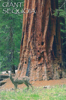
GIANT SEQUOIA
SIERRA NEVADA MOUNTAINS, CALIFORNIA
The giant sequoia are the largest living things on earth. They can be seen in the greatest numbers in Cavaleras Big Trees State Park and Kings Canyon, Sequoia and Yosemite National Parks. The deer in the foreground is a mule deer.
Sent by Heather, a postcrosser from USA.
This is from Wikipedia : Sequoiadendron giganteum (giant sequoia, Sierra redwood, Sierran redwood, or Wellingtonia) is the sole living species in the genus Sequoiadendron, and one of three species of coniferous trees known as redwoods, classified in the family Cupressaceae in the subfamily Sequoioideae, together with Sequoia sempervirens (Coast Redwood) and Metasequoia glyptostroboides (Dawn Redwood). The common use of the name "sequoia" generally refers to Sequoiadendron, which occurs naturally only in groves on the western slopes of the Sierra Nevada Mountains of California.
The genus Sequoiadendron includes a single extinct species, S. chaneyi.
Giant Sequoias are the world's largest trees in terms of total volume (technically, only 7 living Giant Sequoia exceed the 42,500 cubic feet (1,200 m3) of the Lost Monarch Coast Redwood tree; see Largest trees). They grow to an average height of 50–85 metres (160–279 ft) and 6–8 metres (20–26 ft) in diameter. Record trees have been measured to be 94.8 metres (311 ft) in height and 17 metres (56 ft) in diameter. The oldest known Giant Sequoia based on ring count is 3,500 years old. Sequoia bark is fibrous, furrowed, and may be 90 centimetres (3.0 ft) thick at the base of the columnar trunk. It provides significant fire protection for the trees. The leaves are evergreen, awl-shaped, 3–6 mm long, and arranged spirally on the shoots. The seed cones are 4–7 cm long and mature in 18–20 months, though they typically remain green and closed for up to 20 years; each cone has 30-50 spirally arranged scales, with several seeds on each scale giving an average of 230 seeds per cone. The seed is dark brown, 4–5 mm long and 1 mm broad, with a 1 mm wide yellow-brown wing along each side. Some seed is shed when the cone scales shrink during hot weather in late summer, but most seeds are liberated when the cone dries from fire heat or is damaged by insects.
Giant sequoia regenerates by seed. Trees up to about 20 years old may produce stump sprouts subsequent to injury. Giant sequoia of all ages may sprout from the bole when old branches are lost to fire or breakage, but (unlike coast redwood) mature trees do not sprout from cut stumps. Young trees start to bear cones at the age of 12 years.
At any given time, a large tree may be expected to have approximately 11,000 cones. The upper part of the crown of any mature Giant Sequoia invariably produces a greater abundance of cones than its lower portions. A mature giant sequoia has been estimated to disperse from 300,000-400,000 seeds per year. The winged seeds may be carried up to 180 m (600 ft) from the parent tree.
Lower branches die fairly readily from shading, but trees less than 100 years old retain most of their dead branches. Trunks of mature trees in groves are generally free of branches to a height of 20–50 m, but solitary trees will retain low branches.
Ireland - Gallarus Oratory
Shaped like an upturned boat the Gallarus Oratory is believed to be an early Christian church located on the Dingle Peninsular, Co. Kerry and built between the 6th century and 9th century. According to local legend, if a person climbs out of the oratory via the window, their soul will be cleansed.
Sent by Claudia, a WiP partner from Ireland.
This is from Wikipedia : The Gallarus Oratory (Irish: Séipéilín Ghallarais, literally "The Church of the Place of the Foreigners") is believed to be an early Christian church located on the Dingle Peninsula, County Kerry, Ireland. Though the building is believed to have been built between the 6th century and 9th century, some believe it could have been built as late as the 12th century because the east window has a rounded top made of two carved stones (not a true arch). According to local legend, if a person climbs out of the oratory via the window, their soul will be cleansed.
As early as the 6th century, monastic settlements were being built in remote areas of Ireland. This small oratory, built without mortar, uses corbel vaulting, a technique developed by Neolithic tomb-makers. It is dimly lit, with only a tiny window opposite the entrance door. Shaped like an upturned boat, this miniature church overlooks the harbour at Ard na Caithne (formerly also called Smerwick) on the Dingle Peninsula.
It is a corbelled-roofed building, built with the stones being laid at a slight angle, lower on the outside than on the inside, thus allowing rainwater to run off. This design has kept the interior relatively dry despite the lack of mortaring, allowing the building to remain in excellent condition.
"In Gallarus Oratory" (1969) is a poem written by Seamus Heaney.
Turkey - Eskişehir Çağdaş Cam Sanatları Müzesi
China - The Tiger Hill
The Tiger Hill.
Sent by Li, a postcrosser from China.
This is from Wikipedia : Tiger Hill (Chinese: 虎丘; pinyin: Hŭqiū) is a hill in Suzhou, in China. It is a popular tourist destination and is known for its natural beauty as well as historical sites. The hill is so named because it is said to look like a crouching tiger. Another legend states that a white tiger appeared on the hill to guard it following the burial of King Helü. The hill is sometimes referred to in parallel with "Lion Mountain", another hill near Suzhou which clearly resembles a sitting lion.
The hill has been a tourist destination for hundreds, if not thousands, of years, as is evident from the poetry and calligraphy carved into rocks on the hill.
Its features include:
* Sword-Testing Rock: a rock in two pieces that was supposedly cleaved cleanly by a legendary sword of extraordinary sharpness.
* Spring of Simplicity and Honesty: a well that, according to legend, first appeared as a spring to an exhausted monk carrying water up the entire length of the hill.
* Yunyan Pagoda: a pagoda seven stories in height whose main architectural feature is its lean; it in fact predates the Leaning Tower of Pisa.
* Sword Pond (Jianchi): a small rectangular pond, beneath which a treasure of some 3000 swords are believed to have been buried; this site is not excavated because the Leaning Pagoda's foundations rest on the site.
* Lu Yu Well: a well attributed to Lu Yu, author of the first book on tea.
* Thousand People Rock (Chinese: 千人石; pinyin: qiān rén shí).
According to the Historical Records, the Wu King Helu was buried on the hill, called then "the Hill Emerging from the Sea". The legend goes that three days after his burial a white tiger appeared squatting on the hill. Hence the name. It has an elevation of over 30 m. and covers about 49.41ac. Tiger Hill boasts impressive rocks, deep dales, 3 matchless scenes, 9 suitable occasions for enjoyment, 18 scenic spots, and changing scenery at all times. No wonder it has been an awe-inspiring sight in the area south of the Lower Yangtze. The Yunyan Temple Pagoda and the Sword Pool are well-known features of the hill. With a history going back more than 1,000 years, the simple, archaic and imposing Yunyan Temple Pagoda, also known as the Second Leaning Tower on earth, stands aloft at the top of the hill, serving as a symbol of ancient Suzhou for years, The Tomb of the Wu King Helu under the Sword Pool has remained an unsolved mystery for two and a half millennia. The story goes that the great Jin master Wang Xizhi traded his calligraphy for lovable geese from the Taoist Abbot. And the windy vale and cloudy spring make the visitor reluctant to leave.
Ukraine - National Costume
Subscribe to:
Posts (Atom)