Friday, May 27, 2011

Cocos (Keeling) Islands - Jukong Race


Jukong Race
Cocos (Keeling) Islands, Indian Ocean.

Sent by Kakak Norana from Cocos (Keeling) Islands. This is our first of the four postcards from Cocos (Keeling Islands.

This is from Wikipedia : The Territory of the Cocos (Keeling) Islands, also called Cocos Islands and Keeling Islands, is a territory of Australia, located in the Indian Ocean, southwest of Christmas Island and approximately midway between Australia and Sri Lanka.

The territory consists of two atolls and 27 coral islands, of which two, West Island and Home Island, are inhabited with a total population of approximately 600.

The Cocos (Keeling) Islands consist of two flat, low-lying coral atolls with an area of 14.2 square kilometres (5.5 sq mi), 26 kilometres (16 mi) of coastline, a highest elevation of 5 metres (16 ft) and thickly covered with coconut palms and other vegetation. The climate is pleasant, moderated by the southeast trade winds for about nine months of the year and with moderate rainfall.[citation needed] Cyclones may occur in the early months of the year.

North Keeling Island is an atoll consisting of just one C-shaped island, a nearly closed atoll ring with a small opening into the lagoon, about 50 metres (160 ft) wide, on the east side. The island measures 1.1 square kilometres (270 acres) in land area and is uninhabited. The lagoon is about 0.5 square kilometres (120 acres). North Keeling Island and the surrounding sea to 1.5 km (0.93 mi) from shore form the Pulu Keeling National Park, established on 12 December 1995. It is home to the only surviving population of the endemic, and endangered, Cocos Buff-banded Rail.

South Keeling Islands is an atoll consisting of 24 individual islets forming an incomplete atoll ring, with a total land area of 13.1 square kilometres (5.1 sq mi). Only Home Island and West Island are populated. The Cocos Malays maintain weekend shacks, referred to as pondoks, on most of the larger islands.

There are no rivers or lakes on either atoll. Fresh water resources are limited to water lenses on the larger islands, underground accumulations of rainwater lying above the seawater. These lenses are accessed through shallow bores or wells.

Cocos (Keeling) Island is located on almost exactly the opposite side of the globe from Cocos Island, Costa Rica.


Netherlands - Field of Sunflowers


Field of Sunflowers.

Sent by Petra, a postcrosser from Netherlands.

Italy - Historic Center of Naples (3)


Images of Naples (Napoli).

Sent by Mario, a postcrosser from Calitri, Italy.

United Kingdom - England - Leicester


LEICESTER
Top : Church of St. James the Greater, and Victoria Park.
Bottom : Victoria Park and the University of Leicester, and De Monfort Hall.

Sent by Georgina, a postcrosser from England.

This is from Wikipedia : Leicester (/ˈlɛstǝr/ les-tər) is a city and unitary authority area in the East Midlands area of England. It is also the county town of Leicestershire. The city lies on the River Soar and at the edge of the National Forest. In 2006, the population of the Leicester unitary authority was estimated at 289,700, the largest in the East Midlands, whilst 441,213 people lived in the wider Leicester Urban Area. Eurostat's Larger Urban Zone listed the population of the area at 772,400 people as of 2004. Leicester is the 10th most populous settlement in the United Kingdom using the 2001 census definitions and the urban area is the fifteenth largest conurbation in the UK, the second largest in the region behind the Nottingham Urban Area.

Ancient Roman pavements and baths remain in Leicester from its early settlement as Ratae Corieltauvorum, a Roman military outpost in a region inhabited by the Celtic Corieltauvi tribe. Following the demise of Roman society the early medieval Ratae Corieltauvorum is shrouded in obscurity, but when the settlement was captured by the Danes it became one of five fortified towns important to the Danelaw. The name "Leicester" is thought to derive from the words castra of the "Ligore", meaning a camp on the River Legro, an early name for the River Soar[citation needed]. Leicester appears in the Domesday Book as "Ledecestre". Leicester continued to grow throughout the Early Modern period as a market town, although it was the Industrial Revolution that facilitated an unparalleled process of unplanned urbanisation in the area.

A newly constructed rail and canal network routed through the area stimulated industrial growth in the 19th century, and Leicester became a major economic centre with a variety of manufacturers engaged in engineering, shoemaking and hosiery production. The economic success of these industries, and businesses ancillary to them resulted in significant urban expansion into the surrounding countryside. The boundaries of Leicester were extended throughout the 19th and 20th centuries, becoming a county borough in 1889, and granted city status in 1919.

Today, Leicester is located on the Midland Main Line and close to the M1 motorway. The city has a large ethnic minority population, particularly of South Asian origin, a product of immigration to the United Kingdom since the Second World War. To cater for the South Asian community, there are many Hindu, Sikh and Muslim places of worship and the Melton Road district serves as a focus, containing large numbers of Asian restaurants and other small businesses. Leicester is a centre for higher education, with both Leicester University and De Montfort University being based in the city.

Thursday, May 26, 2011

USA - New Mexico - Carlsbad Caverns National Park (1)


CARLSBAD CAVERNS NATIONAL PARK
NEW MEXICO

Carlsbad Caverns National Park contains 113 of more than 300 caves that can be found beneath the surface of the Chihuahuan Desert and Guadalupe Mountains of the southeastern New Mexico and west Texas.

Sent by Robyn from New Mexico, USA.

The park covers a segment of the Permian fossil Capitan Reef.

An extensive cave system has developed within the reef as a result of sulphuric acid dissolution and of the 81 known caves, Carlsbad Cavern is the largest and Lechuguilla Cave is the most extensive and decorated cave in the world.

The Capitan Reef complex dates back to the Permian period, some 280-225 million years ago. The exposed sections of this reef lying within the park are among the best preserved in the world accessible for scientific study. Geologists are able to study the rock formations not only through cave passages which penetrate the reef but also in exposures uncovered through erosion. Fossils include bryozoans, pelecypods, gastropods, echinoderms, brachiopods, fusulinds, sponges, trilobites and algae. Above-ground vegetation communities range from desert to coniferous forest. Some 800 plant species have been identified, of which three are internationally threatened: Sneed pincushion cactus, Lee pincushion cactus and Lloyd's hedgehog cactus. The fauna inventory includes 64 mammals, 331 bird and 44 herpetofauna species.

The caves are noted for their migratory bat species, especially the Mexican free-tailed bat. Various species of fungi and bacteria growing in the caves are of particular scientific and medical interest.

Disturbances within the park include permanent damage incurred to speleothems and the cave ecosystem from tourism, decline in bat populations from the use of DDT as well as attempts to eradicate them in Mexico, oil and gas exploration, grazing by trespassing livestock, invasion by exotic fauna and the hunting of puma.

Carlsbad is radically different from the other existing World Heritage caves: Carlsbad Caverns National Park is distinguished by its huge chambers which are far larger than similar other as well as for its decorative mineral.

Since its initial exploration in 1985, Lechuguilla Cave has been strictly managed, allowing only closely monitored visits by researchers. This cave is particularly noteworthy as an underground laboratory where geological processes can be studied in a virtually undisturbed environment. The only threat that faces the park is oil and gas exploration near its borders. (Source)

USA - New Mexico - State Bird


ROADRUNNER
NEW MEXICO
The Geococcyx californiacus, commonly known as the Roadrunner, is a speedy member of the cuckoo family and New Mexico's state bird.

Sent by Robyn from New Mexico, USA.

"The roadrunner was designated the official state bird of New Mexico in 1949. Also called the chaparral bird, the roadrunner (Geococcyx californianus) inhabits desert and shrubby country in the southwestern United States and northern Mexico.

Although a roadrunner is capable of flight, it spends most of the time on the ground, running at speeds of 15 miles per hour (or more) to catch its prey (insects, small reptiles, rodents, tarantulas, scorpions and small birds). The Hopi and Pueblo Indian tribes believed that the roadrunner provided protection against evil spirits."(Source)

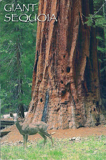
USA - California - Giant Sequoia


GIANT SEQUOIA
SIERRA NEVADA MOUNTAINS, CALIFORNIA

The giant sequoia are the largest living things on earth. They can be seen in the greatest numbers in Cavaleras Big Trees State Park and Kings Canyon, Sequoia and Yosemite National Parks. The deer in the foreground is a mule deer.

Sent by Heather, a postcrosser from USA.

This is from Wikipedia : Sequoiadendron giganteum (giant sequoia, Sierra redwood, Sierran redwood, or Wellingtonia) is the sole living species in the genus Sequoiadendron, and one of three species of coniferous trees known as redwoods, classified in the family Cupressaceae in the subfamily Sequoioideae, together with Sequoia sempervirens (Coast Redwood) and Metasequoia glyptostroboides (Dawn Redwood). The common use of the name "sequoia" generally refers to Sequoiadendron, which occurs naturally only in groves on the western slopes of the Sierra Nevada Mountains of California.

The genus Sequoiadendron includes a single extinct species, S. chaneyi.

Giant Sequoias are the world's largest trees in terms of total volume (technically, only 7 living Giant Sequoia exceed the 42,500 cubic feet (1,200 m3) of the Lost Monarch Coast Redwood tree; see Largest trees). They grow to an average height of 50–85 metres (160–279 ft) and 6–8 metres (20–26 ft) in diameter. Record trees have been measured to be 94.8 metres (311 ft) in height and 17 metres (56 ft) in diameter. The oldest known Giant Sequoia based on ring count is 3,500 years old. Sequoia bark is fibrous, furrowed, and may be 90 centimetres (3.0 ft) thick at the base of the columnar trunk. It provides significant fire protection for the trees. The leaves are evergreen, awl-shaped, 3–6 mm long, and arranged spirally on the shoots. The seed cones are 4–7 cm long and mature in 18–20 months, though they typically remain green and closed for up to 20 years; each cone has 30-50 spirally arranged scales, with several seeds on each scale giving an average of 230 seeds per cone. The seed is dark brown, 4–5 mm long and 1 mm broad, with a 1 mm wide yellow-brown wing along each side. Some seed is shed when the cone scales shrink during hot weather in late summer, but most seeds are liberated when the cone dries from fire heat or is damaged by insects.

Giant sequoia regenerates by seed. Trees up to about 20 years old may produce stump sprouts subsequent to injury. Giant sequoia of all ages may sprout from the bole when old branches are lost to fire or breakage, but (unlike coast redwood) mature trees do not sprout from cut stumps. Young trees start to bear cones at the age of 12 years.

At any given time, a large tree may be expected to have approximately 11,000 cones. The upper part of the crown of any mature Giant Sequoia invariably produces a greater abundance of cones than its lower portions. A mature giant sequoia has been estimated to disperse from 300,000-400,000 seeds per year. The winged seeds may be carried up to 180 m (600 ft) from the parent tree.

Lower branches die fairly readily from shading, but trees less than 100 years old retain most of their dead branches. Trunks of mature trees in groves are generally free of branches to a height of 20–50 m, but solitary trees will retain low branches.

Japan - Pictorial Map


Pictorial Map of Japan.

Sent by Masayo, a postcrosser from Tokyo, Japan.

Ireland - Gallarus Oratory


Shaped like an upturned boat the Gallarus Oratory is believed to be an early Christian church located on the Dingle Peninsular, Co. Kerry and built between the 6th century and 9th century. According to local legend, if a person climbs out of the oratory via the window, their soul will be cleansed.

Sent by Claudia, a WiP partner from Ireland.

This is from Wikipedia : The Gallarus Oratory (Irish: Séipéilín Ghallarais, literally "The Church of the Place of the Foreigners") is believed to be an early Christian church located on the Dingle Peninsula, County Kerry, Ireland. Though the building is believed to have been built between the 6th century and 9th century, some believe it could have been built as late as the 12th century because the east window has a rounded top made of two carved stones (not a true arch). According to local legend, if a person climbs out of the oratory via the window, their soul will be cleansed.

As early as the 6th century, monastic settlements were being built in remote areas of Ireland. This small oratory, built without mortar, uses corbel vaulting, a technique developed by Neolithic tomb-makers. It is dimly lit, with only a tiny window opposite the entrance door. Shaped like an upturned boat, this miniature church overlooks the harbour at Ard na Caithne (formerly also called Smerwick) on the Dingle Peninsula.

It is a corbelled-roofed building, built with the stones being laid at a slight angle, lower on the outside than on the inside, thus allowing rainwater to run off. This design has kept the interior relatively dry despite the lack of mortaring, allowing the building to remain in excellent condition.

"In Gallarus Oratory" (1969) is a poem written by Seamus Heaney.

Turkey - Eskişehir Çağdaş Cam Sanatları Müzesi


Eskişehir Çağdaş Cam Sanatları Müzesi or Eskişehir's Modern Glassware Arts Museum.

Sent by Deniz, a postcrosser from Turkey.

Juhannustaika


Aino-Maija Metsola 2007 :
"Juhannustaika".

Sent by Ilkka, a postcrosser from Vaasa, Finland.

China - The Tiger Hill


The Tiger Hill.

Sent by Li, a postcrosser from China.

This is from Wikipedia : Tiger Hill (Chinese: 虎丘; pinyin: Hŭqiū) is a hill in Suzhou, in China. It is a popular tourist destination and is known for its natural beauty as well as historical sites. The hill is so named because it is said to look like a crouching tiger. Another legend states that a white tiger appeared on the hill to guard it following the burial of King Helü. The hill is sometimes referred to in parallel with "Lion Mountain", another hill near Suzhou which clearly resembles a sitting lion.

The hill has been a tourist destination for hundreds, if not thousands, of years, as is evident from the poetry and calligraphy carved into rocks on the hill.

Its features include:

* Sword-Testing Rock: a rock in two pieces that was supposedly cleaved cleanly by a legendary sword of extraordinary sharpness.
* Spring of Simplicity and Honesty: a well that, according to legend, first appeared as a spring to an exhausted monk carrying water up the entire length of the hill.
* Yunyan Pagoda: a pagoda seven stories in height whose main architectural feature is its lean; it in fact predates the Leaning Tower of Pisa.
* Sword Pond (Jianchi): a small rectangular pond, beneath which a treasure of some 3000 swords are believed to have been buried; this site is not excavated because the Leaning Pagoda's foundations rest on the site.
* Lu Yu Well: a well attributed to Lu Yu, author of the first book on tea.
* Thousand People Rock (Chinese: 千人石; pinyin: qiān rén shí).

According to the Historical Records, the Wu King Helu was buried on the hill, called then "the Hill Emerging from the Sea". The legend goes that three days after his burial a white tiger appeared squatting on the hill. Hence the name. It has an elevation of over 30 m. and covers about 49.41ac. Tiger Hill boasts impressive rocks, deep dales, 3 matchless scenes, 9 suitable occasions for enjoyment, 18 scenic spots, and changing scenery at all times. No wonder it has been an awe-inspiring sight in the area south of the Lower Yangtze. The Yunyan Temple Pagoda and the Sword Pool are well-known features of the hill. With a history going back more than 1,000 years, the simple, archaic and imposing Yunyan Temple Pagoda, also known as the Second Leaning Tower on earth, stands aloft at the top of the hill, serving as a symbol of ancient Suzhou for years, The Tomb of the Wu King Helu under the Sword Pool has remained an unsolved mystery for two and a half millennia. The story goes that the great Jin master Wang Xizhi traded his calligraphy for lovable geese from the Taoist Abbot. And the windy vale and cloudy spring make the visitor reluctant to leave.

Ukraine - National Costume


Girls in national costumes. 1902. Pidvarky, Kyiv Province.

Sent by Sveta, a postcrosser from Kyiv, Ukraine.

Monday, May 23, 2011

USA - Virginia - State Bird


Cardinal or Northern Cardinal.
Because of its striking beauty and its widespread habitat, teh cardinal is the official bird of seven states; Virginia, West Virginia, North carolina, Kentucky, Ohio, Indiana, and Illinois.

Sent by John, a postcrosser from Virginia, USA.

"Virginia designated the northern cardinal (Cardinalis cardinalis) as official state bird in 1950. One of America's favorite backyard birds, cardinals are distinctive in appearance and song - known for their "cheer cheer cheer," "whit-chew whit-chew" and "purty purty purty" whistles.

Male cardinals are a brilliant scarlet red, females a buffy brown with reddish wings - both have a jet -black mask, pronounced crest, and heavy bill. The cardinal sings nearly year-round, and the male aggressively defends his 4-acre territory (male cardinals have been seen attacking small red objects mistaken as other males).

Northern cardinals breed 2-3 times each season. The female builds the nest and tends the hatchlings for about 10 days while the male brings food. The male then takes over the care of this first brood while the female moves on to a new nest and lays a second clutch of eggs.

The cardinal is the state bird of 7 states: Illinois, Indiana, Kentucky, North Carolina, Ohio, Virginia, and West Virginia"(Source)

USA - Ohio - State Bird (2)


CARDINAL
Ohio State Bird.

Sent by Terence, a postcrosser from Ohio, USA.

"Ohio designated the northern cardinal (Cardinalis cardinalis) as official state bird in 1933. One of America's favorite backyard birds, cardinals are distinctive in appearance and song - known for their "cheer cheer cheer," "whit-chew whit-chew" and "purty purty purty" whistles.

Male cardinals are a brilliant scarlet red, females a buffy brown with reddish wings - both have a jet -black mask, pronounced crest, and heavy bill. The cardinal sings nearly year-round, and the male aggressively defends his 4-acre territory (male cardinals have been seen attacking small red objects mistaken as other males).

Northern cardinals breed 2-3 times each season. The female builds the nest and tends the hatchlings for about 10 days while the male brings food. The male then takes over the care of this first brood while the female moves on to a new nest and lays a second clutch of eggs.

The cardinal is the state bird of 7 states: Illinois, Indiana, Kentucky, North Carolina, Ohio, Virginia, and West Virginia."(Source)

Germany - St. Peter-Ording


St. Peter-Ording
Sunset on the sand bank.

Sent by Ute, a postcrosser from North Germany.

This is from Wikipedia : Sankt Peter-Ording is a very popular German seaside spa and a municipality in the district of Nordfriesland, in Schleswig-Holstein, Germany. It is the only German seaside resort that has a sulphur spring and thus terms itself "North Sea healing spa and sulphur spring". By overnight stays, St. Peter-Ording is the largest German seaside spa in Germany, and it has the most overnight stays in Schleswig-Holstein.

St. Peter-Ording is situated on the North Sea coast, on the western tip of the Eiderstedt peninsula, approx. 45 km southwest of Husum. Part of the municipality lies in the Schleswig-Holstein Wadden Sea National Park. Its characteristics include a beach that is approximately 12 kilometers long and up to one kilometre wide, the dunes, the salt meadows and the cultivated forested areas, atypical for this region. The salt meadows are of special ecological importance, since they belong to the few salt meadows that remain in their natural state. In contrast to other salt meadows along the North Sea they contain numerous ponds and puddles. The landward side is flooded with sea water only occasionally and not every year, so that amphibians such as grass frogs, moor frogs and toads (Bufo bufo) live uncharacteristically close to the seashore. Even the Natterjack Toad (Bufo calamita) is able to reproduce successfully in this environment.

The normal range of the tides is up to three meters. In the intertidal mudflat walks the tidal calendar should always be consulted. That the beach is so flat and smooth has made it a popular site for sail-racing, a sport similar to wind-surfing but on wheels. There are several elevated walkways through the dunes giving access to the beach.

Sunday, May 22, 2011

France - Département du Gard


Département du Gard.

Sent by Christiane, a postcrosser from France.

This is from Wikipedia : Gard (Occitan: Gard) is a département located in southern France in the Languedoc-Roussillon region.

The department is named after the River Gard, although the formerly Occitan name of the River Gard, Gardon, has been replacing the traditional French name in recent decades, even among French speakers.

The Gard area was settled by the Romans in classical times. It was crossed by the Via Domitia, which was constructed in 118 BC.

Gard is one of the original 83 departments created during the French Revolution on March 4, 1790. It was created from the ancient province of Languedoc.

It was originally intended to include the canton of Ganges in the department which would have been geographically logical, but Ganges was transferred to the neighbouring department of Hérault at the outset. In return, Gard received from Hérault the fishing port of Aigues Mortes which gave the department its own outlet to the Gulf of Lion.

During the middle of the nineteenth century the prefecture, traditionally a centre of commerce with a manufacturing sector focused on textiles, was an early beneficiary of railway development, becoming an important railway junction. Several luxurious hotels were built, and the improved market access provided by the railways also encouraged, initially, a rapid growth in wine growing: however, many of the department's viticulturalists were ruined by the arrival in 1872 of phylloxera.

Gard is part of the region of Languedoc-Roussillon and is surrounded by the departments of Hérault, Lozère, Aveyron, Bouches-du-Rhône, Vaucluse, and Ardèche.

The highest point in the department is the Mont Aigoual.

Serious flooding has occurred in the department in recent years.

Brazil - Salvador


View of Salvador city.

Sent by André, a postcrosser from Brazil.

Germany - Neuschwanstein Castle (2)


Royal castle Neuschwanstein.

Sent by Petra, a postcrosser from Germany.

Lithuania - The Presidency


The Presidency (Presidential Palace) on Independence Day (Feb 16th).

Sent by Vytas, a postcrosser from Vilnius, Lithuania.

This is from Wikipedia : The Presidential Palace (Lithuanian: Prezidentūra, , Polish: Pałac Biskupi)), located in Vilnius Old Town, is the official office and eventual official residence of the President of Lithuania. The palace dates back to the 14th century and during its history it has undergone various reconstructions, supervised by prominent architects, including Laurynas Gucevičius and Vasily Stasov. In 1997 the palace became the official seat of the President of Lithuania.

The Palace traces its history back to the 14th century, when Jogaila, the Grand Duke of Lithuania, issued an edict donating land in the city to the Vilnius Diocese, for this reason the palace is sometimes referred to as the Bishops' Palace. Construction of the Palace took place in the late 14th century under the auspices of the first Bishop of Vilnius Andrzej Jastrzębiec, and over succeeding generations, the building was gradually enlarged and renovated. During the Renaissance the Palace was once again renovated, and parks and gardens surrounding the building were expanded.

As the 18th century unfolded, a number of dramatic events in the Palace's history took place: the last Bishop of Vilnius lived in the Palace, Lithuania was annexed by the Russian Empire, and the building itself was badly damaged by two major fires in 1737 and 1748. The Palace was reconstructed in 1750 under the supervision of the architect Laurynas Gucevičius. After its reconstruction the Palace was used as a residence for Emperors, Kings and noblemen. During 1796, Tsar Paul I lived at the Palace. During the course of the 19th century the Palace served as a residence for several Imperial Russian governors, such as Mikhail Muravyov, nicknamed "The Hangman". It was also visited by the future King of France, Louis XVIII in 1804.

In 1812, both the Russian Tsar Alexander I and the French Emperor Napoleon used the Palace as their residence. During Napoleon’s invasion of Russia, he organized military operations and Lithuanian army units from this Palace, including five regiments of infantry, four cavalry regiments, and the National Guard of Vilnius. He received Lithuanian noblemen, newly appointed officials of the administration, and other dignitaries in this Palace as well. After Napoleon's defeat in 1812, the Palace was used for ceremonial proposes; it was here that then-general Mikhail Kutuzov was awarded Russia's highest military award - the Order of St. George. During 1824-1834, the Palace was reconstructed by the prominent St. Petersburg architect Vasily Stasov in the Empire style, under supervision of Karol Podczaszyński. Stasov's reconstruction of the Palace has remained to this day.

After Lithuania regained its independence in 1918, the Palace housed the Ministry of Foreign Affairs and the ELTA news agency until it ended up in Poland in 1920. It was restored in the 1930s by Stefan Narębski. After the Second World War, the Palace served as the Military Officers' Centre; later it housed various Lithuanian artists. The Palace was gradually adapted for use as a presidential office, and since 1997 it has served as the official office of the President of Lithuania. Currently adaptations are underway to expand the palace's functions to also serve as the president's official residence. A flag displaying the coat of arms of the President is hoisted when the President is present in the Palace or in the city.

Ukraine - Chersones Basilica


Chersones Basilica, an ancient Greek city, part of Chersonesus Taurica.

Sent by Natalie, a postcrosser from Sevastopol, Crimea.

This is from Wikipedia : Chersonesus Taurica (Greek: Χερσόνησος, Chersonēsos; Latin: Chersonesus; Byzantine Greek: Χερσών; Old East Slavic: Корсунь, Korsun; Ukrainian and Russian: Херсонес, Khersones; also transliterated as Chersonese, Chersonesos, Cherson) is an ancient Greek colony founded approximately 2500 years ago in the southwestern part of Crimea, known then as Taurica. The colony was established in the 6th century BC by settlers from Heraclea Pontica. Currently the site is part of the National Historical-Archeological Museum-Zapovednik of Ukraine "Khersones Tavriysky".

The ancient city is located on the shore of the Black Sea at the outskirts of Sevastopol on the Crimean peninsula of Ukraine, where it is referred to as Khersones. It has been nicknamed the "Ukrainian Pompeii" and "Russian Troy". The name "Chersonesos" in Greek means simply "peninsula", and aptly describes the site on which the colony was established. It should not be confused with the Tauric Chersonese, the name often applied to the whole of the southern Crimea along with "Taurica".

During much of the classical period the town was a democracy ruled by a group of elected archons and a council called the Damiorgi. As time went on the government grew more oligarchic, with power concentrated in the hands of the archons. A form of oath sworn by all the citizens in the 3rd century BC has survived to the present day.

Saturday, May 21, 2011

Armenia - Mountain Ararat


Mountain Ararat, 5,165 m.

Sent by Raneve from Yerevan, Armenia. Terima kasih (thanks). This is among the hardest to get. Raneve was back in USA late last year and sent me a card from Florida and told me she has mailed this card from Armenia. The postmarked on the stamps was on 28 April 2011 :) and took only about three weeks to reach Malaysia.

This is from Wikipedia : Mount Ararat is a snow-capped, dormant volcanic cone in Turkey. It has two peaks: Greater Ararat (the tallest peak in Turkey, and the entire Armenian plateau with an elevation of 5,137 m/16,854 ft) and Lesser Ararat (with an elevation of 3,896 m/12,782 ft).

The Ararat massif is about 40 km (25 mi) in diameter. The Iran-Turkey boundary skirts east of Lesser Ararat, the lower peak of the Ararat massif. It was in this area that by the Tehran Convention of 1932 a border change was made in Turkey's favor, permitting her to occupy the eastern flank of the massif.

Mount Ararat in Judeo-Christian tradition is associated with the "Mountains of Ararat" where according to the book of Genesis, Noah's ark came to rest. It also plays a significant role in Armenian nationalism and irredentism.

Mount Ararat is located in the Eastern Anatolia Region of Turkey between Doğubayazıt and Iğdır, near the border with Iran, Armenia and Nakhchivan exclave of Azerbaijan, between the Aras and Murat Rivers. Its summit is located some 16 km (10 mi) west of the Iran and 32 km (20 mi) south of the Armenian border. The Ararat plain runs along its northwest to western side.

Albania - Old City of Appolonia


Ruins of the old city Appolonia close to the Podni village

Sent by Natalya from Nadym, Russia. Terima kasih (thanks).

Note : Still looking/waiting for the first postcard sent stamped and postmarked from Albania.

Azerbaijan - Mausoleum of Qarabaglar


The mausoleum of Qarabaglar, Sharur. It is supposed that the monument was erected in the 12 - 13th century in the village of Qarabaglar in Sharur.

Sent by Natalya from Nadym in Russia. Terima kasih (thank you).

Note : Still looking/waiting for the first postcard sent stamped and postmarked from Azerbaijan.

Canada - The Rogers Centre


The Rogers Centre was the first stadium to have a rectangle roof. This roof covers 8 acres and could fit a 31 storey apartment building inside. It opened in June 1989 and is home to the Toronto Blue Jays and the Toronto Argonauts.

Sent by Melanie from Ontario, Canada.

This is from Wikipedia : Rogers Centre (originally SkyDome) is a multi-purpose stadium, in Downtown Toronto, Ontario, Canada, situated next to the CN Tower, near the shores of Lake Ontario.

Originally opened in 1989, it is home to the American League's Toronto Blue Jays, the CFL's Toronto Argonauts and, as of 2008, the NFL's Buffalo Bills' second playing venue in the Bills Toronto Series.

While it is primarily a sports venue, it also hosts other large-scale events such as conventions, trade fairs, concerts, funfairs, and monster truck shows.

The stadium was renamed "Rogers Centre" following the purchase of the stadium by Rogers Communications, which also owns the Toronto Blue Jays, in 2005.

The venue was noted for being the first stadium to have a fully-retractable motorized roof, as well as for the 348-room hotel attached to it, with 70 rooms overlooking the field. It is also the most recent North American major-league stadium built to accommodate both football and baseball.

The stadium will be the centrepiece of the 2015 Pan American Games as the site of the opening and closing ceremonies.