This is a project of collecting postcards from all over the world.
Wednesday, February 29, 2012
Australia - Southern Hairy-nosed Wombat
Southern Hairy-nosed Wombat (Lasiorhinus latifrons).
Sent by Laurent, a postcrosser from New South Wales, Australia.
This is from Wikipedia : The Southern Hairy-nosed Wombat (Lasiorhinus latifrons) is one of three species of wombats. It is found in scattered areas of semi-arid scrub and mallee from the eastern Nullarbor Plain to the New South Wales border area. It is the smallest of all three wombat species. The young often do not survive dry seasons. It is the state animal of South Australia.
The oldest southern hairy-nosed wombats ever documented were a male and a female from Brookfield Zoo just outside of Chicago. Their names were Carver, who lived to be 34, and his mother, Vicky, who lived to be 24.
The southern hairy-nosed wombat has a stocky and robust build adapted for digging. It is plantigrade and digs with its flattened claws found on each of its 5 digits. The body length ranges 772–934 millimetres (30.4–36.8 in) with a body mass ranging 19–32 kilograms (42–71 lb). It has a short tail that is hidden by its fur. The pelage is silky and ranges in colour from grey to tan. The second and third toes of the wombat’s hind feet are mostly conjoined, apart from their terminal joints, forming a digit with two claws which the wombat uses for grooming. The head is robust and flattened with extended, pointed ears. The snout is pig-like. The animal gets its name from the soft fur covering its rhinarium. The wombat's incisors resemble those of rodents and have molars with a wide palate between them. All the teeth grow continuously throughout its life, which is likely an adaptation to its harsh diet. Compared to the common wombat, the southern hairy-nosed wombat has a better developed temporalis muscle and a more reduced masseter muscle. It is also distinguished from the northern hairy-nosed wombat, with its nasal bone being longer than the frontal bone.
USA - Arizona - Navajo Children
ARIZONA
Navajo children carefree and lighthearted carry on the tradition and heritage of the southwest native Americans.
Sent by Kristen, a postcrosser from USA.
This is from Wikipedia : The Navajo (Navajo: Diné or Naabeehó) of the Southwestern United States are the largest single federally recognized tribe of the United States of America. The Navajo Nation has 300,048 enrolled tribal members. The Navajo Nation constitutes an independent governmental body which manages the Navajo Indian reservation in the Four Corners area of the United States. The Navajo language is spoken throughout the region, although most Navajo speak English as well.
Until they came into contact with the Spanish and Pueblos, the Navajo were hunters and gatherers. They adopted farming techniques and crops from the Pueblo people, growing mainly corn, beans, and squash. As a result of Spanish influence, they began herding sheep and goats, depending on them for food and trade. They spun and wove sheared wool into blankets and clothing which could be used for personal use or trading. They also depended on their flocks of sheep for meat. Their lives depended on sheep so much that, to the Navajo, sheep were a kind of currency and the size of the herd was a mark of social status.
The Navajo speak dialects of the language family referred to as Athabaskan. The Navajo and Apache are believed to have migrated from northwestern Canada and eastern Alaska, where the majority of Athabaskan speakers reside. The Dene First Nations, who live near from Tadoule Lake in Manitoba to the Great Slave Lake in Northwest Territories, also speak Athabaskan languages. Despite the time elapsed, these people reportedly can still understand the language of their distant cousins the Navajo. Archaeological and historical evidence suggests that the Athabaskan ancestors of the Navajo and Apache entered the Southwest by 1400 CE. Navajo oral traditions are said to retain references of this migration.
Navajo oral history also seems to indicate a long relationship with Pueblo people[12] and a willingness to adapt foreign ideas into their own culture. Trade between the long-established Pueblo peoples and the Athabaskans was important to both groups. The Spanish records say by the mid-16th century, the Pueblos exchanged maize and woven cotton goods for bison meat, hides and material for stone tools from Athabaskans who either traveled to them or lived around them. In the 18th century, the Spanish reported that the Navajo had large numbers of livestock and large areas of crops. The Navajo probably adapted many Pueblo ideas into their own different culture.
The Spanish first used the term Apachu de Nabajo in the 1620s to refer to the people in the Chama Valley region east of the San Juan River and northwest of present-day Santa Fe, New Mexico. By the 1640s, they were using "Navajo" for these indigenous people. The Spanish recorded in 1670s that they lived in a region called Dinetah, about sixty miles (100 km) west of the Rio Chama valley region. In the 1780s, the Spanish sent military expeditions against the Navajo in the southwest and west of that area, in the Mount Taylor and Chuska Mountain regions of New Mexico.
In the last 1,000 years, Navajos have had a history of expanding their range and refining their self-identity and their significance to other groups. This probably resulted from a cultural combination of endemic warfare (raids) and commerce with the Pueblo, Apache, Ute, Comanche and Spanish peoples, set in the changing natural environment of the Southwest.
Netherlands - Den Helder
Greetings From Den Helder.
Sent by Antonet, a postcrosser from Netherlands.
This is from Wikipedia : Den Helder is a municipality and a city in the Netherlands, in the province of North Holland. Den Helder occupies the northernmost point of the North Holland peninsula. It is home to the country's main naval base.
The Royal TESO ferryboat service operates the transportation link between Den Helder and the nearby Dutch Wadden island of Texel to the north.
The municipality of Den Helder consists of the following cities, towns, villages and/or districts: Den Helder, Huisduinen, Julianadorp, and the hamlets Friese Buurt and De Kooy.
The major areas of Den Helder are Old Den Helder, Nieuw-Den Helder, and De Schooten. Nieuw-Den Helder was built in the 1950s, following World War II, when there was a great need for additional housing. De Schooten was constructed in the 1960s.
Huisduinen was the original older part of the city, whereas Helder itself was a nearby smaller hamlet. Due to its strategic location at the tip of the North Holland peninsula, multiple fortifications were built in the area. The area likely began being called Helledore ("Hell's Door" or "Hell's Gate", later on Den Helsdeur) because of the "hellish" fortifications that prevented enemy ships from sailing into the Zuyderzee. The name Helder may also have come from Helle/Helde, which means hill or hilly grounds, or from Helre, which means a sandy ridge.
Den Helder has played an important part in Dutch shipping. During the Dutch Golden Age, ships would be assembled near Den Helder and sail from there the world's oceans. During the 1820s, the North Holland Canal was dug from Amsterdam to Den Helder. The lighthouse Lange Jaap was built in 1877 and is the tallest cast-iron lighthouse in Europe, at 63.45 meters (208.2 ft).
Tuesday, February 28, 2012
Monday, February 27, 2012
Germany - Frankenthal
Multiviews of Frankenthal.
Sent by Sabine, a WiP partner from Germany.
This is from Wikipedia : Frankenthal is a town in southwestern Germany, in the state of Rhineland-Palatinate.
Frankenthal was first mentioned in 772. In 1119 an Augustinian monastery was built here, the ruins of which — known, after the founder, as the Erkenbertruine — still stand today in the town centre.
In the second half of the 16th century, people from the Netherlands, persecuted for their religious beliefs, settled in Frankenthal. They were industrious and artistic and brought economic prosperity to the town. Some of them were important carpet weavers, jewellers and artists whose Frankenthaler Malerschule ("Frankenthal school of painting") acquired some fame. In 1577 the settlement was raised to the status of a town by the Count Palatine Johann Casimir.
In 1600 Frankenthal was converted to a fortress. In 1621 it was besieged by the Spanish during the Thirty Years' War, and then successively occupied by troops of the opposing sides. Trade and industry were ruined and the town was not reconstructed until 1682.
In 1689 the town was burnt to the ground by French troops in the War of the Grand Alliance. The town did not fully recover from this for more than fifty years.
However, in 1750, under the rule of the Elector (Kurfürst) Charles Theodore, Frankenthal was established as a centre of industry. Numerous factories were opened and mulberry trees were planted for silk production. In 1755 the famous Frankenthal porcelain factory was opened, which remained in production until 1800.
In 1797 the town came under French occupation during the French Revolutionary Wars. It passed into the rule of Bavaria in 1816.
The beginning of modern industrialisation is dated from 1859.
In 1938 the Jewish synagogue, built in 1884, was burnt to the ground during the Kristallnacht.
In 1943 during a bombing raid the centre of the town was almost completely destroyed. In 1945, at the end of World War II, its industries in ruins, it was occupied first by the Americans and then by the French.
From 1946 Frankenthal has been part of the federal state of Rhineland-Palatinate. Today the town is again the site of some medium sized industries.
USA - Utah - Arches National Park (2)
Arches National Park, Utah.
Sent by Dagmar, a postcrosser from Potsdam, Germany.
This is from Wikipedia : Arches National Park is a U.S. National Park in eastern Utah. It is known for preserving over 2000 natural sandstone arches, including the world-famous Delicate Arch, in addition to a variety of unique geological resources and formations.
The park is located just outside of Moab, Utah, and is 76,679 acres (31,031 ha) in area. Its highest elevation is 5,653 feet (1,723 m) at Elephant Butte, and its lowest elevation is 4,085 feet (1,245 m) at the visitor center. Forty-three arches have collapsed due to erosion since 1970. The park receives 10 inches (250 mm) of rain a year on average.
Administered by the National Park Service, the area was originally created as a National Monument on April 12, 1929. It was redesignated as a National Park on November 12, 1971.
The national park lies atop an underground evaporite layer or salt bed, which is the main cause of the formation of the arches, spires, balanced rocks, sandstone fins, and eroded monoliths in the area. This salt bed is thousands of feet thick in places, and was deposited in the Paradox Basin of the Colorado Plateau some 300 million years ago when a sea flowed into the region and eventually evaporated. Over millions of years, the salt bed was covered with debris eroded from the Uncompahgre Uplift to the northeast. During the Early Jurassic (about 210 Ma) desert conditions prevailed in the region and the vast Navajo Sandstone was deposited. An additional sequence of stream laid and windblown sediments, the Entrada Sandstone (about 140 Ma), was deposited on top of the Navajo. Over 5000 feet (1500 m) of younger sediments were deposited and have been mostly eroded away. Remnants of the cover exist in the area including exposures of the Cretaceous Mancos Shale. The arches of the area are developed mostly within the Entrada formation.
The weight of this cover caused the salt bed below it to liquefy and thrust up layers of rock into salt domes. The evaporites of the area formed more unusual salt anticlines or linear regions of uplift. Faulting occurred and whole sections of rock subsided into the areas between the domes. In some places, they turned almost on edge. The result of one such 2,500-foot (760 m) displacement, the Moab Fault, is seen from the visitor center.
As this subsurface movement of salt shaped the landscape, erosion removed the younger rock layers from the surface. Except for isolated remnants, the major formations visible in the park today are the salmon-colored Entrada Sandstone, in which most of the arches form, and the buff-colored Navajo Sandstone. These are visible in layer cake fashion throughout most of the park. Over time, water seeped into the surface cracks, joints, and folds of these layers. Ice formed in the fissures, expanding and putting pressure on surrounding rock, breaking off bits and pieces. Winds later cleaned out the loose particles. A series of free-standing fins remained. Wind and water attacked these fins until, in some, the cementing material gave way and chunks of rock tumbled out. Many damaged fins collapsed. Others, with the right degree of hardness and balance, survived despite their missing sections. These became the famous arches.
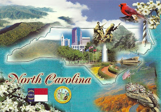
USA - North Carolina - Mapcard (2)
NORTH CAROLINA
The Tarheel State
State Bird : Cardinal
State Flower : Dogwood
Sent by Debbie, a postcrosser from North Carolina, USA.
This is from Wikipeedia : Tar Heel (or Tarheel) is a nickname applied to the state and inhabitants of North Carolina as well as the nickname of the University of North Carolina athletic teams, students, alumni, and fans.
The exact etymology of the nickname is unknown, but most experts believe its roots come from the fact that tar, pitch and turpentine created from the vast pine forests were one of North Carolina's most important exports early in the state's history.
Because the exact history of the term is unknown, a number of legends have developed to explain it. Many believe it to be a nickname given during the U.S. Civil War, because of the state's importance on the Confederate side, and the fact that the troops "stuck to their ranks like they had tar on their heels".
The term "Tar Heel" gained popularity during the Civil War.
In its early years as a colony, North Carolina settlements became an important source of the naval stores tar, pitch, and turpentine especially for the English navy. Tar and pitch were largely used to paint the bottom of wooden British ships in order to both seal the ship and to prevent shipworms from damaging the hull.
At one time, an estimated 100,000 barrels (16,000 m3) of tar and pitch were shipped annually to England. After 1824, North Carolina became the leader in the United States for naval stores. By the Civil War, North Carolina had more than 1600 turpentine distilleries, and two thirds of all turpentine in the United States came from North Carolina and one-half from the counties of Bladen and New Hanover.
Historians Hugh Lefler and Albert Newsome claim in North Carolina: the History of a Southern State (3rd edition, 1973) that North Carolina led the world in production of naval stores, from about 1720 to 1870.
At the time, tar was created by piling up pine logs and burning them until hot oil seeped out from a canal. The vast production of tar from North Carolina led many, including Walt Whitman, to give the derisive nickname of "Tarboilers" to the residents of North Carolina. North Carolina was nicknamed the "Tar and Turpentine State" because of this industry.
Somehow, these terms evolved until the nickname Tar Heel was used to refer to residents of North Carolina and gained prominence during the American Civil War. During this time, the nickname Tar Heel was a pejorative, but starting around 1865, the term began to be used as a source of pride.
In 1893, the students of the University of North Carolina founded a newspaper and christened it The Tar Heel, which was later renamed The Daily Tar Heel. By the early 1900s the term was embraced by many as a non-derisive term for North Carolinians by those from inside and outside the state of North Carolina.
Sunday, February 26, 2012
Ukraine - Kiev
Thursday, February 23, 2012
Wednesday, February 22, 2012
USA - Ohio - Mapcard (1)
OHIO
"Buckeye State"
Extending 225 miles from east to west and 215 miles from north to south, Ohio's inland location gives the state a continental climate of warm summers and cool winters. Ohio abounds with state parks, forest and other outdoor recreational areas, as well as resorts, beaches, and boating and fishing facilities. From farmlands to bustling metropolitan cities, Ohio provides its travelers with beautiful memories of scenic wonders.
Capital : Columbus. Flower : Scarlet Carnation. Bird : Cardinal. Tree : Ohio Buckeye.
Sent by Laurence, a postcrosser from Ohio, USA.
Golden Orioles (Oriolus oriolus)
Golden Orioles (Oriolus oriolus).
Sent by Christine, a postcrosser from Germany.
This is from Wikipedia : The Eurasian Golden Oriole or simply Golden Oriole (Oriolus oriolus) is the only member of the oriole family of passerine birds breeding in northern hemisphere temperate regions. It is a summer migrant in Europe and western Asia and spends the winter season in the central and southern Africa.
Golden orioles have an extremely large range with large populations that are apparently stable. Therefore, they are evaluated as least concern by BirdLife International.
The male is striking in the typical oriole black and yellow plumage, but the female is a drabber green bird. Orioles are shy, and even the male is remarkably difficult to see in the dappled yellow and green leaves of the canopy.
In flight they look somewhat like a thrush, strong and direct with some shallow dips over longer distances.
The New World orioles are similar in appearance to the Oriolidae, but are icterids unrelated to the Old World birds.
The breeding range of this species spans from Portugal, Spain and France across the United Kingdom and Scandinavia to Poland, Russia, the Balkans, Turkey and West Asia to the Caucasus up to Mongolia and China. They winter in central and southern Africa. They generally migrate during the night, but may travel during the day in the spring migration. During the fall migration they migrate via the Eastern Mediterranean where they feed on fruit; they are often considered a pest in this region because of this.
The Eurasian Golden Oriole inhabits a range of habitats. In Western Europe they prefer open broadleaf forests and plantations, copses, riverine forest, orchards, large gardens; in Eastern Europe they may inhabit more continuous forest as well as mixed or coniferous forests. They generally avoid treeless habitats but may forage there. In their wintering habitat they are fond in semi-arid to humid woodland, tall forests, riverine forest, woodland/savanna mosaic and savanna.
They feed on insects and fruit. They build neat nests in tree forks and lay 3-6 eggs.
Their call is a screech like a jay, but the song is a beautiful fluting weela-wee-ooo or or-iii-ole, unmistakable once heard.
USA - Alaska - Denali National Park (3)
Tuesday, February 21, 2012
China - Mount Qingcheng and the Dujiangyan Irrigation System
Mount Qingcheng and the Dujiangyan Irrigation System.
Sent by Doris, a postcrosser from Guangzhou, China.
This is from UNESCO : The Dujiangyan Irrigation System, begun in the 2nd century BC, is a major landmark in the development of water management and technology, and is still discharging its functions perfectly. It graphically illustrates the immense advances in science and technology achieved in ancient China. The temples of Mount Qingcheng are closely associated with the foundation of Taoism, one of the most influential religions of East Asia over a long period of history.
In 256 BC Li Bing, Shu Kingdom magistrate of the Qin dynasty, selected the mountain outlet of the Minjiang River, with its abundant water flow, as the site for an irrigation system. This involved cutting the Lidui platform, digging canals to avoid the risk of flooding, and opening up a navigation route; at the same time the neighbouring farmland would be irrigated, creating a 'Land of Abundance'.
During the Tang dynasty (618-907) large-scale water conservancy and irrigation projects were carried out. The system was rationalized during the Song dynasty (960-1279) into three main water-courses, three canals and fourteen branches, with coordinated maintenance and water control. During the Yuan dynasty (1206-1368) additional projects were carried out, and this process continued throughout the Ming dynasty (1368-1644). Incessant warfare at the end of the Ming dynasty and the early years of the Qing dynasty (1644-1913) resulted in the system falling into disrepair, but this was eventually set to rights.
In AD 142 the philosopher Zhang Ling founded the doctrine of Taoism on Mount Qingcheng, and in the following year he took up permanent residence in what became known as the Celestial Cave of the Tianshi (the name given to the spiritual head of the Taoist religion). During the Jin dynasty (265-420) a number of Taoist temples were built on the mountain, and it became the centre from which the teachings of Taoism were disseminated widely throughout China.
The irrigation system consists of two principal components, the Weir Works and the irrigated area. The Weir Works form the heart of the system. It receives water from the upper valley of the Minjiang River. There are three main elements. The Yuzui Bypass Dyke is located at the outfall of the Minjiang River. Water from the upper valley is diverted into the Outer and Inner Canals: the former follows the course of the Minjiang River and the latter flows to the Chengdu plain through the Baopingkou Diversion Passage. It serves the essential function of bypassing the considerable amount of silt brought down by the river. It makes full use of the bend, directing surface water with low concentrations of silt into the Inner Canal and the heavily silted deeper water into the Outer Canal.
The Feiyashan Floodgate is situated between the lower end of the Yuzui Bypass Dyke and the V-Shaped Dyke. Its upper end is 710 m from the Bypass Dyke and 120 m from the Baopingkou Diversion Passage. The principal function of the Floodgate is to transfer overflow, together with silt and pebbles, from the Inner to the Outer Canal. When water flow in the Inner Canal is low, the Floodgate ceases its draining function and transfers water into the Weir Works to ensure the supply of irrigation water to the Chengdu Plains. The Baopingkou Diversion Passage lies between the Lidui Platform south of Dujiangyan City and the cliff facing it, an enormous engineering project that dates back to the beginning of the Irrigation System in the 3rd century BC. It is able to control and maintain the water flow to the Chengdu irrigated plains automatically, even in periods of drought or flooding.
Mount Qingcheng dominates the Chengdu plains. There are eleven temples on Mount Qingcheng of special significance in the field of Taoist architecture because, unlike Mount Wudang temples, they do not reproduce the features of imperial courts but the traditional architecture of western Sichuan. The Erwang Temple west of Dujiangyan City was considerably enlarged during the Song dynasty (960-1279) and substantially reconstructed in the 17th century. It is constructed of wood and is located on a commanding point of the mountain, overlooking the river. The carvings inside the temple record the history and achievements of water control.
Australia - New South Wales
Monday, February 20, 2012
South Korea - Gu Hye-seon/Ku Hye Sun
Gu Hye-seon in a scene of "Boys Over Flowers".
Sent by Yunjeong, a postcrosser from South Korea.
This is from Wikipedia : Ku Hye Sun (Korean: 구혜선, born November 9, 1984) is a South Korean actress, singer, author and director. An admirer of Leonardo Da Vinci, Ku also dabbles in directing, writing, illustrating, singing and composing. She is best known for her role as Geum Jan Di in the hit TV show Boys Over Flowers.
Ku entered the entertainment industry after gaining popularity on the internet as an ulzzang. She soon rose to fame in the drama Pure in Heart and surprised critics with her performance in the historical drama The King and I. Ku is most well known for portraying Geum Jan-di in the hit KBS drama Boys Over Flowers. After a year in limbo with no broadcasting slot, her pre-produced drama The Musical finally aired in September 2011. Ku will next star in the Taiwanese drama adaptation of the manga Absolute Boyfriend and is currently filming for the upcoming SBS series Take Care of Us, Captain.
Originally set to debut as a singer (supposedly in a 3-member girl group with 2NE1's Park Bom and Sandara Park), YG Entertainment CEO Yang Hyun-seok advised Ku to pursue acting rather than music. In recent years, she has displayed her vocal talents through Saranga (which became the title song of Pure in Heart), a cover of Shim Soo-bong's I Don't Know Anything But Love (which played during a crucial scene in Boys Over Flowers), and a duet of Kim Gun Mo's song Rain Falls on a Sleepless Night with Big Bang member Seungri on the music talk show Lee Hana's Peppermint. Ku has also composed an album of New Age music titled Breath.
Ku wrote Tango, a semi-autobiographical novel about a twenty-something woman's experience with love and relationships. The book was a bestseller, selling 30,000 copies within a week. Its release coincided with her first solo art exhibition, also titled Tango, in July 2009 at La Mer Gallery, which attracted 10,000 visitors. The exhibition featured around 40 of Ku's illustrations, some from her novel. She has also done artwork for Gummy's fourth album Comfort.
Ku made her official debut as a director through her short film The Madonna (Korean title translates to The Cheerful Caretaker) at the 2009 Puchon International Fantastic Film Festival. She has since written and directed her first feature-length film Magic, and her second film The Peach Tree premiered at the 2011 Busan International Film Festival.
In 2011 Ku established her own company, Ku Hye-sun Film, and she will produce and film her projects under its name, which will offer her a measure of legal/business protection.
Ukraine - Kiev
Saturday, February 18, 2012
Russia - Russian UNESCO World Heritage Sites
Russian UNESCO World heritage Sites.,
Gefsimansky Skit, Sergiev Posad; Qol Sharif Mosque, Kazan; Church on Spilt Blood, St. Petersburg.
Saint Basil's Cathedral, Moscow; Dormition Cathedral, Vladimir; Kizhi Pogost, Kizhi Island.
Church of Christ's Ascension, Kolomenskoye; The Cathedral of the Annunciation, Kazan; The Kremlin, Moscow.
Sent by Tatiana, a postcrosser from Moscow, Russia.
United Kingdom - England - North Norfolk Mapcard
A mapcard showing interesting places in North Norfolk.
Sent by Audrey, a postcrosser from England.
This is from Wikipedia : North Norfolk is a local government district in Norfolk, United Kingdom. Its council is based in Cromer. The council headquarters can be found approximately 1 mile (1.6 km) out of the town of Cromer on the Holt Road.
The district was formed on 1 April 1974, under the Local Government Act 1972. It was a merger of Cromer Urban District, North Walsham Urban District, Sheringham Urban District, Wells-next-the-Sea Urban District, Erpingham Rural District, Smallburgh Rural District, and Walsingham Rural District.
The district was originally to be called Pastonacres, but changed its name by resolution of the council and permission of the Secretary of State for Environment before it formally came into existence on 1 April 1974.
Friday, February 17, 2012
Puerto Rico - Tropical Flowers
Tropical Flowers, Puerto Rico
From top left : Heliconia Hibiscus, Frangipani, Ginger (gengibre), Banana, Orchid (orquidea), Heliconia and Bromeliad.
Sent by Jare from Puerto Rico.
Ukraine - Lviv
Lviv - A multicultural city.
Sent by Daria, a postcrosser from Kiev, Ukraine.
This is from Wikipedia : Lviv (Ukrainian: Львів L’viv, IPA: [lʲwiu̯]; Polish: Lwów, pronounced [lvuf]; Russian: Львов, L'vov; German: Lemberg; Latin: Leopolis; see also other names) is a city in western Ukraine. The city is regarded as one of the main cultural centres of today's Ukraine and historically has also been a major Polish and Jewish cultural center, as Poles and Jews were the two main ethnicities of the city until the outbreak of World War II and the following Holocaust and Polish population transfers (1944–1946). The historical heart of Lviv with its old buildings and cobblestone roads has survived World War II and ensuing Soviet presence largely unscathed. The city has many industries and institutions of higher education such as the Lviv University and the Lviv Polytechnic. Lviv is also a home to many world-class cultural institutions, including a philharmonic orchestra and the famous Lviv Theatre of Opera and Ballet. The historic city centre is on the UNESCO World Heritage List. Lviv celebrated its 750th anniversary with a son et lumière in the city centre in September 2006.
Lviv was founded in 1256 in Red Ruthenia by King Danylo Halytskyi of the Ruthenian principality of Halych-Volhynia, and named in honour of his son, Lev. Together with the rest of Red Ruthenia, Lviv was captured by the Kingdom of Poland in 1349 during the reign of Polish king Casimir III the Great. Lviv belonged to the Crown of the Kingdom of Poland 1349–1772, the Austrian Empire 1772–1918 and the Second Polish Republic 1918–1939. With the Invasion of Poland at the outbreak of the second World War, the city of Lviv with adjacent land were annexed and incorporated into the Soviet Union, becoming part of the Ukrainian Soviet Socialist Republic from 1939 to 1941. Between July 1941 and July 1944 Lviv was under German occupation and was located in the General Government. In July 1944 it was captured by the Soviet Red Army and the Polish Home Army. According to the agreements of the Yalta Conference, Lviv was again integrated into the Ukrainian SSR. Most of the Poles living in Lviv were resettled into Polish territories annexed from Germany.
After the collapse of the Soviet Union in 1991, the city remained a part of the now independent Ukraine, for which it currently serves as the administrative centre of Lviv Oblast, and is designated as its own raion (district) within that oblast.
On 12 June 2009 the Ukrainian magazine Focus assessed Lviv as the best Ukrainian city to live in. Its more Western European flavor lends it the nickname the "Little Paris of Ukraine".
The city is expecting a sharp increase in the number of foreign visitors next summer for the 2012 UEFA European Football Championship, and as a result a major new airport terminal is being built. Lviv is one of 8 Polish and Ukrainian cities that is co-hosting the group stages of the tournament.
USA - California - Mapcard (2)
Subscribe to:
Posts (Atom)