Sunday, June 2, 2013

Spain - Zaragoza


ZARAGOZA

Sent by Helena from Zaragoza in Spain.

Zaragoza (Spanish pronunciation: [θaɾaˈɣoθa]), also called Saragossa in English, is the capital city of the Zaragoza province and of the autonomous community of Aragon, Spain. It is situated on the Ebro river and its tributaries, the Huerva and the Gállego, near the centre of the region, in a valley with a variety of landscapes, ranging from desert (Los Monegros) to thick forest, meadows and mountains.
On 1 September 2010 the population of the city of Zaragoza was 701,090, within its administrative limits on a land area of 1,062.64 km² (410.29 sq mi), ranking fifth in Spain. It is the 35th most populous municipality in the European Union. The population of the metropolitan area was estimated in 2006 at 783,763 inhabitants. The municipality is home to more than 50 percent of the Aragonese population. The city lies at an elevation of 199 metres.
Zaragoza hosted Expo 2008 in the summer of 2008, a world's fair on water and sustainable development. It was also candidate for the European Capital of Culture in 2016.
The city is famous for its folklore, a renowned local gastronomy, and landmarks such as the Basílica del Pilar, La Seo Cathedral and the Aljafería Palace. Together with La Seo and the Aljafería, several other buildings form part of the Mudéjar Architecture of Aragon which is a UNESCO World Heritage Site. The Fiestas del Pilar are among the most celebrated festivals in Spain. (read further)


Togo


Kiana (TravBuddy friend) from New York was volunteering in an orphanage. She said there's no postcard of Togo because there's not enough tourism in Togo. She bargained for this authentic hand painting art.

Terima kasih Kiana for sending this from Lome, Togo.


Christmas Island - Migration of Christmas Island Red Crab


Christmas Island National Park
Migration of Christmas Island Red Crab Gecarcoidea natalis

Sent by The General Manager of The Sunset. Terima kasih banyak-banyak (thank you very much).


Sweden - Varberg Radio Station


World Heritage Grimeton Radio Station.

Sent by Jennie and staff at the Radio Station.

The Varberg radio station at Grimeton is an exceptionally well-preserved example of a type of telecommunication centre, representing the technological achievements by the early 1920s, as well as documenting further development over some three decades (read further)


France - Franche-Comté - 25 Doubs - Besançon - Fortifications of Vauban


Besançon
The citadels built by Vauban.

Sent by Barbara, a postcrosser from France.

Fortifications of Vauban consists of 12 groups of fortified buildings and sites along the western, northern and eastern borders of France. They represent the finest examples of the work of Sébastien Le Prestre de Vauban (1633-1707), a military engineer of King Louis XIV. The serial property includes towns built from scratch by Vauban, citadels, urban bastion walls and bastion towers. There are also mountain forts, sea forts, a mountain battery and two mountain communication structures. This property is inscribed as bearing witness to the peak of classic fortifications, typical of western military architecture. Vauban also played a major role in the history of fortification in Europe and on other continents until the mid-19th century. (Source)


USA - Hawai'i - Haleakalā National Park


Haleakalā National Park

Sent by David, a postcrosser from Indiana, USA.

Haleakalā National Park is a United States national park located on the island of Maui in the state of Hawaiʻi. The park covers an area of 33,265 acres (134.62 km2), of which 19,270 acres (77.98 km2) is a wilderness area. In 2000 the name was changed by the Hawaiian National Park Language Correction Act of 2000 observing the Hawaiian spelling.
It was originally created as part of the Hawaii National Park along with the volcanoes of Mauna Loa and Kilauea on the island of Hawaiʻi in 1916. Hawaii Volcanoes National Park was made into a separate national park in 1961. The park area was designated an International Biosphere Reserve in 1980. The name Haleakalā is Hawaiian for "house of the sun." According to a local legend, the demigod Maui imprisoned the sun here in order to lengthen the day.
The park features the dormant Haleakalā (East Maui) Volcano, which last erupted sometime between 1480 and 1600 AD.The park is divided into two distinct sections: the summit area and the coastal Kipahulu area.
The two sections of the park average 1,450,000 visitors per year. (read further)


USA - Arizona - Mapcard


ARIZONA
THE GRAND CANYON STATE
Becoming the 48th state on February 14, 1912, Arizona is ranked sixth in size among all the states. Phoenix, the state's capital since 1889, is also its largest city.  Arizona has 15 national monuments (more than any other state) in areas of historic or scenic interest, including Indian ruins, canyons and deserts. The state is famus for its cactus and plants, and the Saguaro cactus blossom is the state flower. Arizona's official state bird is the cactus wren.

Sent by Nancy, a postcrosser from Arizona, USA


Spain - Valladolid


Monuments in Valladolid.

Sent by Juan and Vanessa from Valladolid, Spain.

Valladolid (Spanish pronunciation: [baʎaðoˈlið]) is the capital city of the autonomous region of Castile and León and the Province of Valladolid in north-western Spain. It is situated at the confluence of the Pisuerga and Esgueva rivers, and located within threewinegrowing regions: Ribera del Duero, Rueda and Cigales. It has a population of 311,501 people, making it Spain's 13th most populous municipality and northwestern Spain's biggest city.  Its metropolitan area ranks 20th in Spain with a population of 413,605 people in 23 municipalities (INE 2011).
Valladolid was originally settled in pre-Roman times by the Celtic Vaccaei people, and later the Romans themselves. It remained a small settlement until being re-established by King Alfonso VI of Castile as a Lordship for the Count Pedro Ansúrez in 1072. It grew to prominence in the Middle Ages as the seat of the Court of Castile and being endowed with fairs and different institutions as a collegiate church, UniversityRoyal Court and Chancery and the Casa de la Moneda.  The Catholic MonarchsIsabel I of Castile and Ferdinand II of Aragon, married in Valladolid in 1469 and established it as the capital of the Kingdom of Castile and later of united Spain. Christopher Columbus died in Valladolid in 1506, while authors Francisco de Quevedo and Miguel de Cervantes lived and worked in the city. It was also a cultural centre in the Spanish Renaissance, although a fire in 1561 forcedPhillip II to move the capital to Madrid. It briefly returned to Valladolid under Phillip III between 1601 and 1606, before returning indefinitely to Madrid. The city then declined until the arrival of the railroad in the 19th century, and with its industrialisation, already in the 20th century. (read further)


Tuesday, May 28, 2013

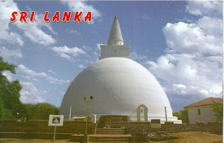
Sri Lanka - Sacred City of Anuradhapura (2)


Mirisawetti Cheitiya - Anuradhapura

Sent by Jayasekara from Sri Lanka.


Sri Lanka - Sacred City of Anuradhapura (1)


Lankaramaya - Anuradhapura

Sent by Jayasekara from Sri Lanka.

Anuradhapura attests in a unique and specific way to the Sinhalese civilization. On numerous occasions the city was submitted to the assaults of invaders from southern India - Tamils, Pandyas, Cholas, etc. It stands as a permanent manifesto of the culture of Sri Lanka, impervious to outside influences. The sacred city exerted a considerable influence on the development of architecture during several centuries. It includes remarkable monuments, particularly the Dagabas of colossal size, placed on circular foundations and surrounded by a ring of monolithic columns, characteristic of the Sinhalese stupas.
The city is one of the principal shrines of Buddhism. The cutting from the fig tree of Buddha, brought there in the 3rd century BC, has flourished and, today, the Bodhi tree spreads out over the centre of the site from a sanctuary near the Brazen Palace. The relics of Siddharta have, moreover, shaped the religious topography of Anuradhapura, where the Dagaba Thuparama was built by King Tissa in the 3rd century BC to house the clavicle of Buddha, an important religious relic presented by Ashoka.
Founded during the 4th century BC, Anuradhapura quickly became both the capital of Ceylon and the sacred city of Buddhism on the island. The Chronicles of Mahanam, a narrative written 1,000 years later, affirms that it was founded in 380 BC by Prince Pandukabhaya.
Towards 250 BC, King Ashoka sent his son Mahinda to convert Tissa, the grandson of Pandukabhaya, and the latter became the first Buddhist sovereign (devanampiya) of Ceylon. A second mission, led by Sanghamitta, Buddhist nun and daughter of Ashoka, brought Tissa a cutting from the Ashvattha, the sacred fig tree of Bodhgaya, under which Siddharta attained spiritual enlightenment and supreme wisdom.
With the exception of the period of the invasion of the Tamil princes, at the beginning of the 2nd century BC, Anuradhapura remained the political and religious capital of Ceylon during 10 centuries. Its apogee was reached under the reign of Dutthagamani who, in 161 BC, expelled the Tamil invaders, re-established Buddhism in the place of Brahminism and endowed the site with extraordinary monuments: Dagaba Minisaweti, Dagaba Rubanwelisaya, the Brazen Palace, etc.
Anuradhapura was sacked and taken by the Pandyan kings during the 9th century and then returned against payment of a ransom.
The majority of the monuments were restored but the city never recovered after its destruction in AD 993 by King Chola Rajaraja I. Having lost its position as capital, it was deserted in favour of Polonnaruwa. (Source)

Thursday, May 23, 2013

Palestine - Jerusalem


General view of the city of Jerusalem with the Dome of the Rock.

Sent by Zuhair from Nābulus in Palestine.


The border of Jerusalem is a particularly delicate issue, with each side asserting claims over this city. The three largest Abrahamic religions—Judaism, Christianity, and Islam—include Jerusalem as an important setting for their religious and historical narratives. Israel asserts that the city should not be divided and should remain unified within Israel's political control. Palestinians claim at least the parts of the city which were not part of Israel prior to June 1967. As of 2005, there were more than 719,000 people living in Jerusalem; 465,000 were Jews (mostly living in West Jerusalem) and 232,000 were Muslims (mostly living in East Jerusalem). (read further)


Belize - Butterfly Falls


Butterfly Falls, Mountain Pine Ridge
Cayo District, Belize C.A.

Sent by Linda, a TravBuddy member from Belize.


Butterfly Falls is one of the many tucked away cascades and falls on on top of Pine Ridge, Cayo District, Belize. I highly recommend visiting this entire area. This area displays a completely different side of Belize. There are vast pine forests up here in sharp contrast to the lush jungle and rain forest below. There are a number of truly excellent lodges to stay here as well.  In this case, Hidden Valley Inn was kind enough to grant me permission to freely roam their 7,200 acres of preserve. (Source)


USA - Washington D.C.


WASHINGTON DC
US Capitol, Washington Monument and Lincoln Memorial.

Sent by Ashlee, a postcrosser from Virginia, USA.


Bicycle (37)


Sent by Ria, a postcrosser who lives near Eindhoven, Netherlands.


Bicycle (36)


Sent by Kerry, a postcrosser from Canada.


Wednesday, May 22, 2013

Romania - Churches of Moldavia (2)


ROMANIA
Mănăstirea Humor or Humor Monastery, a part of Churches of Moldavia, a UNESCO World Heritage Site.

Sent by Marius, a postcrosser from Romania.


Monday, May 20, 2013

Uzbekistan - Historic Centre of Bukhara


Abdullah Khan Madrasa

Sent by Marina from Tashkent, Uzbekistan.

Bukhara, which is situated on the Silk Route, is some 25 centuries old. It is the most complete example of a medieval city in Central Asia, with an urban fabric that has remained largely intact. Monuments of particular interest include the famous tomb of Ismail Samani, a masterpiece of 10th-century Muslim architecture, and a large number of 17th-century madrasas. The historic part of the city, which is in effect an open-air museum, combines the city's long history in a single ensemble.

Archaeological excavations have revealed that the settlement on the site of latter-day Bukhara became part of the Kushan state as early as the 2nd millennium BC. In the 4th century it was incorporated into the Ephtalite state. Before the Arab conquest Bukhara was one of the largest cities of central Asia, owing its prosperity to its site on a rich oasis and at the crossroads of ancient trade routes. It became a major cultural centre of the Caliphate of Baghdad in 709, and in 892 the capital of the independent Samanid Kingdom. A time of great economic growth came to an end with the sack of the city in 1220 by the Mongol horde of Genghis Khan. It slowly recovered, to become part of the Timurid Empire. The internal strife of the late 15th century led to the occupation of Bukhara by nomadic Uzbek tribesmen led by Khan Sheibani, becoming the capital of the Bukhara Khanate. A long period of unrest and short-lived dynasties ended in 1920, when it was absorbed into the Soviet Union; nevertheless, this period saw Bukhara consolidating its role as a major commercial and cultural centre.
The townscape of latter-day Bukhara represents every stage of the city's history. The earliest monuments include the 10th century Ismail Samani Tomb, the decorated brick minaret of Poi-Kalyan from the 11th century, along with the Magoki Mosque and the Chasma Ayub Shrine. The Timurid period is represented only by the Ulugbek Medresseh. The most celebrated buildings date from the Shebibanid period - the Poi-Kalyan group, the Lyabi-Khauz ensemble, the Kosh Medresseh, and the Gaukushon Medresseh. A little later came the medressehs at important crossroads, such as Taki Sarafon (Dome of the Moneyshangers, Taki-Tilpak-Furushan (Dome of the Headguard Sellers), Tim-Bazzazan, and Tim-Abdullah-Khan. Among the fine buildings erected in the anarchic early 17th century must be included the great new mosque Magoki Kurns (1637) and the imposing Abdullah-Khan Medresseh. It should be stressed, however, that the real importance of Bukhara lies not in its individual buildings but rather in its overall level of urban planning and architecture, which began with the Sheibanid dynasty. (Source)


Japan - Asakusa Sanja Festival


JAPAN
Akasuka Sanja Festival or Sanja Matsuri, Tokyo.

Sent by Yuki, a postcrosser from Tokyo, Japan.

Sanja Matsuri (三社祭?, literally "Three Shrine Festival"), or Sanja Festival, is one of the three great Shinto festivals in Tokyo. It is considered one of the wildest and largest. The festival is held in honor of Hinokuma Hamanari, Hinokuma Takenari and Hajino Nakatomo, the three men who established and founded Sensō-ji. Sanja Matsuri is held on the third weekend of every May atAsakusa Shrine. Its prominent parades revolve around three mikoshi (three portable shrines referenced in the festival's name), as well as traditional music and dancing. Over the course of three days, the festival attracts 1.5 to 2 million locals and tourists every year. (read further)


Friday, May 17, 2013

Marshall Islands - Pearl Of The Pacific


Iokwe
We welcome you to come visit the Republic of the Marshall islands in Magnificent Micronesia. Experience beauty and nature in its finest form.

Sent by MIVA. Thank you.


The Marshall Islands, officially the Republic of the Marshall Islands (Marshallese: Aolepān Aorōkin M̧ajeļ), is an island country located in the northern Pacific Ocean. Geographically, the country is part of the larger island group of Micronesia, with the population of 68,480 people spread out over 34 low-lying coral atolls, comprising 1,156 individual islands and islets. The islands sharemaritime boundaries with the Federated States of Micronesia to the west, Wake Island to the north, Kiribati to the south-east, and Nauru to the south. The most populous atoll is Majuro, which also acts as the capital.

Micronesian colonists gradually settled the Marshall Islands during the 2nd millennium BC, with inter-island navigation made possible using traditional stick charts. Islands in the archipelago were first explored by Europeans in the 1520s, with Spanish explorer Alonso de Salazar sighting an atoll in August 1526. Other expeditions by Spanish and English ships followed, with the islands' current name stemming from British explorer John Marshall. Recognised as part of the Spanish East Indies in 1874, the islands were sold toGermany in 1884, and became part of German New Guinea in 1885. The Empire of Japan occupied the Marshall Islands in World War I, which were later joined with other former German territories in 1919 by the League of Nations to form the South Pacific Mandate. InWorld War II, the islands were conquered by the United States in the Gilbert and Marshall Islands campaign. Along with other Pacific Islands, the Marshall Islands were then consolidated into the United-States-governed Trust Territory of the Pacific IslandsSelf-government was achieved in 1979, and full sovereignty in 1986, under a Compact of Free Association with the United States.

Politically, the Marshall Islands is a presidential republic in free association with the United States, with the US providing defense, funding grants, and access to social services. Having few natural resources, the islands' wealth is based on a service economy, as well as some fishing and agriculture, with a large percentage of the islands' gross domestic product coming from United States aid. The country uses the United States dollar as its currency. The majority of citizens of the Marshall Islands are of Marshallese descent, with small numbers of immigrants from the Philippines and other Pacific islands. The two official languages are Marshallese, a member of the Malayo-Polynesian languages, and English. Almost the entire population of the islands practises some religion, with three-quarters of the country either following the United Church of Christ – Congregational in the Marshall Islands (UCCCMI) or theAssemblies of God. (read further)