Saturday, October 5, 2013

Australia - South Australia


The flag, Sturt's Desert Pea and Southern Hairy-nosed Wombat are emblems of the State of South Australia. Left, top to bottom : Looking over Adelaide, the capital city, from North Adelaide to the Mt Lofty Ranges; a vineyard in the famed Barossa Valley.

Sent by Terry, a postcrosser from Adelaide, Australia.

South Australia (abbreviated as SA) is a state in the southern central part of Australia. It covers some of the most arid parts of the continent. With a total land area of 983,482 square kilometres (379,725 sq mi), it is the fourth largest of Australia's states and territories.
South Australia shares borders with all of the other mainland states, and with the Northern Territory; it is bordered to the west by Western Australia, to the north by the Northern Territory, to the north-east by Queensland, to the east by New South Wales, to the south-east by Victoria, and to the south by the Great Australian Bight and the Indian Ocean. With over 1.6 million people, the state comprises less than 8% of the Australian population and ranks fifth in population among the states and territories. The majority of its people reside in the state capital, Adelaide, with most of the remainder settled in fertile areas along the south-eastern coast and River Murray. The state's origins are unique in Australia as a freely settled, planned British province, rather than as a convict settlement. Official settlement began on 28 December 1836, when the colony was proclaimed at The Old Gum Tree by Governor John Hindmarsh.
The first settlement to be established was Kingscote, Kangaroo Island, on 26 July 1836, five months before Adelaide was founded. The guiding principle behind settlement was that of systematic colonisation, a theory espoused by Edward Gibbon Wakefield that was later employed by the New Zealand Company. The aim was to establish the province as a centre of civilisation for free immigrants, promising civil liberties and religious tolerance. Although its history is marked by economic hardship, South Australia has remained politically innovative and culturally vibrant. Today, the state is known as a state of festivals and of fine wine. The state's economy centres on the agricultural, manufacturing and mining industries and has an increasingly significant finance sector as well.
South Australia's Governor is Kevin Scarce and its Premier is Jay Weatherill of the Australian Labor Party. (Source)


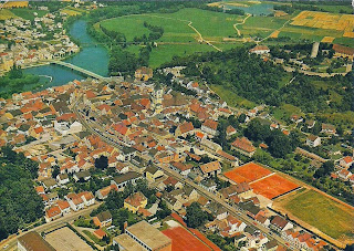
Germany - Bavaria - Burglengenfeld


Burglengenfeld

Sent by Ingrid, a WiP partner from Burglengenfeld, Germany.

Burglengenfeld is a town in the district of Schwandorf, in BavariaGermany. It is situated on the river Naab, 22 km north of Regensburg. (read further)


U.S.A. - California - Sequoia & Kings Canyon National Park (2)


Sequoia National Park
Land of Giants, Sequoia National Park
The establishment of Sequoia National Park in 1890, even in its much smaller form, was a major first step in securing the giant trees and wondrous landscape for future generations. Several annexes and boundary expansions since that time have succeeded in protecting more of the area, but complete success will depend upon our appreciation and protection of the park into the future.

Sent by Sequoia and Kings Canyon National Parks, Three Rivers, California.


U.S.A. - California - Sequoia & Kings Canyon National Parks (1)


SEQUOIA AND KINGS NATIONAL PARKS, CALIFORNIA
The twin national parks of Sequoia and Kings Canyon are located on the southern end of California's Sierra Nevada Mountains. Elevations range from 1,700 feet at Ash Mountain to 14,495 feet at Mount Whitney's summit. Within these parks are found the largest groves of giant sequoia trees and also the largest individual sequoias.

Sent by Sequoia & Kings National Parks, Three Rivers, California.

Sequoia National Park is a national park in the southern Sierra Nevada east of Visalia, California, in the United States. It was established on September 25, 1890. The park spans 404,063 acres (631.35 sq mi; 1,635.18 km2). Encompassing a vertical relief of nearly 13,000 feet (4,000 m), the park contains among its natural resources the highest point in the contiguous 48 United States, Mount Whitney, at 14,505 feet (4,421 m) above sea level. The park is south of and contiguous with Kings Canyon National Park; the two are administered by the National Park Service together.
The park is famous for its giant sequoia trees, including the General Sherman tree, one of the largest trees on Earth. The General Sherman tree grows in the Giant Forest, which contains five out of the ten largest trees in the world. The Giant Forest is connected by the Generals Highway to Kings Canyon National Park's General Grant Grove, home to the General Grant tree among other giant sequoias. The park's giant sequoia forests are part of 202,430 acres (81,921 ha) of old-growth forests shared by Sequoia and Kings Canyon National Parks. Indeed, the parks preserve a landscape that still resembles the southern Sierra Nevada before Euro-American settlement. (read further)


Netherlands - Apeldoorn


Views of Apeldoorn.

Sent by Marieke, a postcrosser from Apeldoorn.

Apeldoorn [ˈaːpəɫdʊːrn] is a municipality and city in the province of Gelderland in the centre of the Netherlands. It is a regional centre. The municipality of Apeldoorn, including villages like BeekbergenLoenen and Hoenderloo, has 157,057 inhabitants (2012). The western half of the municipality lies on the Veluwe ridge, the eastern half lies in the IJssel valley. John Berends of the CDA is the mayor of Apeldoorn. (read further)


U.S.A. - Massachusetts - Mapcard (3)


Massachusetts.

Sent by Cyd, a postcrosser from Massachusetts, USA.


U.S.A. - Idaho - State Flower


IDAHO
A Syringa bush grows along a bank of the Salmon River in Idaho. The Syringa is Idaho's state flower.

Sent by Tracy from Boise, Idaho.

The Syringa (Philadelphus lewisii) was designated the official state flower of Idaho in 1931. Syringa is a woody shrub growing to nine feet tall with with clusters of white, fragrant flowers.

Native American Indians found many uses for the syringa - the wood was used for root digging sticks and to make pipe stems, harpoon shafts, bows, arrows, and snowshoes. The bark and leaves were used to make a soap. (Source)


U.S.A - Nebraska - State Capitol


THE NEBRASKA STATE CAPITOL
LINCOLN, NEBRASKA
The Nebraska State Capitol, with its 400-foot tower, is topped by the 32-foot bronze statue of "The Sower".

Sent by Charlene, from Lincoln, Nebraska.

The Nebraska State Capitol, located in Lincoln, Nebraska, houses the primary executive, judicial, and legislative offices of the U.S. State of Nebraska.
The structure is anchored by a three-story, 437-foot (133 m) square base. This square base houses offices most frequently visited by the public. The second floor (main floor) is home to the Nebraska Supreme Court, the Nebraska Court of Appeals, and the Nebraska Legislature.
From the center of the base, a tower rises 362 feet (110 m), crowned by a gold-tiled dome. The spire—The Sower and its pedestal—add an additional 32 feet (9.8 m) to the building’s height. Common measurements list the capitol at 400 feet (120 m), making it the second-tallest U.S statehouse, surpassed only by the 450-foot (140 m) Louisiana State Capitol.
As the tower was intended for expansion of the Nebraska State Library, the 17-foot (5.2 m) tower floors were originally designed to include loft-like stacks for book storage. By 1925, with government increasing in size, the State of Nebraska decided to redesign the tower to house offices. Tower floors continue to house various offices today.
In total, there are 15 full floor stories in the capitol (three mezzanines also exist within the tower). The 14th floor, Memorial Chamber, is the highest publicly accessible level. At this level, four observatory decks offer views of Lincoln from 245 feet (75 m) above the ground.
Chapter 27.56 of the Lincoln Municipal Code places height restrictions on structures within the designated Capitol Environs District. This code helps to maintain the capitol’s title as the tallest building in Lincoln. The capitol held the title of tallest building in Nebraska until 1969 with the completion of the 478-foot (146 m) Woodmen Tower in downtown Omaha. With the completion of Omaha’s 634-foot (193 m) First National Bank Tower in 2002, the capitol became the third-tallest building in Nebraska.
The building was designed by Bertram Grosvenor Goodhue, who drew upon Classical and Gothic architectural traditions. It was constructed between 1922 and 1932, of Indiana limestone. (Source)


Germany - Upper Middle Rhine Valley (3)


Stolzenfels Castle, part of the Upper Middle Rhine Valley.

Sent by Sabine, a WiP partner from Germany.

Note : The postcard was sent to the wrong address and thanks for the unnamed person who directed this postcard to my address.


Ukraine - Genoese Fortress


Towers of Genoese fortress.

Sent by Yana, a postcrosser from Kiev, Ukraine.

The Genoese Fortress (Ukrainian: Генуезька фортеця) or the Sudak Fortress (Ukrainian: Судацька фортеця) is a fortress located in the city of Sudak in southern Ukraine. It was established by the Venetians in the 12th century and later rebuilt by the Genoese between 1371 and 1469 as a fortified stronghold for their colony on the southern coast of the Crimean peninsula. It is one of three other colonies the Genoese established on the territory of modern-day Ukraine during the 13th-15th centuries.
The fortress was built atop an ancient coral reef formation now located 150 m (492 ft) above sea level. The Genoese Fortress overlooks the city and the surrounding Sudak Bay, located on the northern coast of the Black Sea. The territory is currently part of the Historical-Architectural Sanctuary "Sudak Fortress," a branch of the National Sanctuary "Sophia of Kyiv". It is a candidate UNESCO World Heritage Site, submitted in 2007 by the Ukrainian representatives.
Today, the Genoese Fortress is an important tourist attraction bringing thousands of tourists to the Crimea and Ukraine, exhibiting the authentic 14th century Italian architecture along with a number of archeological artifacts found in the vicinity. Due to its historical significance, the fortress was featured in a number of cinematic films and documentaries. (Source)


Argentina - Buenos Aires


ARGENTINA - Buenos Aires

Sent by Laura from Buenos Aires, Argentina.

Ciudad Autónoma de Buenos Aires(/ˈbwnəs ˈɛərz/ or /ˈrɪs/, Spanish: [ˈbwenos ˈaiɾes]) is the capital and largest city of Argentina, and the second-largest metropolitan area in South America, after Greater São Paulo. It is located on the western shore of the estuary of the Río de la Plata, on the southeastern coast of the South American continent. The Greater Buenos Aires conurbation, which also includes several Buenos Aires Province districts, constitutes the third-largest conurbation in Latin America, with a population of around thirteen million (Source).


Brazil - Brasilia - Cathedral of Brasília


Cathedral of Brasília (Catedral Metropolitana).

Sent by Carol from Brazil.

The Cathedral of Brasília (Catedral Metropolitana Nossa Senhora Aparecida- "Metropolitan Cathedral of Our Lady Aparecida" ) is the Roman Catholic cathedral serving BrasíliaBrazil, and serves as the seat of the Archdiocese of Brasília. It was designed by Oscar Niemeyer, and was completed and dedicated on May 31, 1970. The cathedral is a hyperboloid structure constructed from 16 concrete columns, weighing 90 tons each. (read further)


Friday, August 23, 2013

Georgia - Batumi


Colonnades - Seaside Park
Batumi, Georgia

Sent by Maria of United Kingdom who sent this postcard from Georgia.

Batumi (Georgianბათუმი, formerly known as Batum) is a seaside city on the Black Sea coast and capital of Adjara, anautonomous republic in southwest Georgia. With a population of 180,000 (2008 census), Batumi serves as an important port and a commercial center. It is situated in a subtropical zone, rich in agricultural produce such as citrus fruit and tea. While industries of the city include shipbuilding, food processing, and light manufacturing, most of its economy revolves around tourism. Since 2010, the face of the city has been transformed by the construction of new high-rise landmark buildings and the renovation of the Old Town. (read further)


Romania - Wooden Churches of Maramureş


Ieud, Romania - Wooden Churches of Maramureş

Sent by Raluca, a WiP partner from Romania.

The Maramureş churches are outstanding examples of vernacular religious wooden architecture resulting from the interchange of Orthodox religious traditions with Gothic influences in a specific vernacular interpretation of timber construction traditions, showing a high level of artistic maturity and craft skills.
The region of Maramureş, situated in the north of Transylvania, was formed over time by the fusion of very old geographical and socio-political entities called 'countries'. These 'countries' are united by their geographical environment, composed of mountains once covered by forests and numerous rivers, but also by their history and spiritual life. In the Middle Ages, the rural social structures were founded on community-type villages grouped in each valley, under the general leadership of the Voivodship of Maramureş. The churches of the region were placed under the jurisdiction of the Orthodox monastery of Peri.
The eight churches of Maramureş are monuments based on traditional timber architecture, and stand on bases of stone blocks and pebble fillings. They are:
The Church of the Presentation of the Virgin at the Temple (Bârsana), built in 1720, became a parish church in 1806. A two-level portico, connected by a staircase, was added to the western facade. Because of its plan, the church belongs to the tradition of the Maramureş region, but differs in its smaller size.
The Church of Saint Nicholas (Budeşti) was built in 1643 on the site of a 15th-century church. It is also distinguished by its size and the four pinnacles at the base of the spire, which indicates a link with the neighbouring region of Lapus.
The Church of the Holy Paraskeva, built in 1770, reflects the artistic maturity of its builders. The external architectural elements are highlighted by decorative motifs incised or cut in the wood to create a homogeneous and valuable ensemble.
The Church of the Nativity of the Virgin replaced the one destroyed by the Tatars in 1717. The structure of the inner space, especially the vaults over the naos and narthex, reveals the ingenuity of the builders. The wooden churches of Maramureş usually formed a complex with a cemetery.
The Church of the Holy Archangels (Plopiş) situated in the 'country' of Chioar, shows certain analogies with the church in Şurdeşti, such as the flat roof slightly lowered over the sanctuary, the slender bell tower with four corner pinnacles, and certain elements of the sculpted decor outside. The decoration, painted in 1811 by Stefan, a native of the village, is preserved on the vaults.
The Church of the Holy Parasceve (Poienile Izei) is one of the oldest of the wooden churches of Maramureş (1604), and reveals two phases in the development of such buildings. The first can be seen in the lower part of the walls with a sanctuary based on a square plan, a typical feature of the oldest wooden buildings. In the 18th century, the walls were raised, the naos was covered by a semi-circular vault, and the interior was decorated with paintings. The portico was added during the first half of the 19th century.
The Church of the Holy Archangels (Rogoz), built in 1663, was moved from Suciu in Sus to Rogoz in 1883. It is characterized by a recessed heptagonal sanctuary, a polygonal pronaos, a southern entrance, and a large asymmetrical roof. It is also distinctive for its profusion of decorative sculpture.
The Church of the Holy Archangels (Şurdeşti), built in 1767, synthesises all the features of the wooden churches of Maramureş at the height of their development with, in particular, a double canopy and superposed windows. The two-level portico and its tall bell tower date to the 19th century. In 1783, three shared the task of decorating the inside of the church. (Source)


Russia - Murmansk Oblast - Murmansk Sea Terminal


Murmansk Sea Terminal
Bark "Sedov"

Sent by Anastasia, a postcrosser from Murmansk, Russia.

Murmansk (RussianМу́рманскKildin SamiМурман ланнҍNorthern SamiMurmánskaSkolt SamiMuurman) is a port city and the administrative center of Murmansk OblastRussia, located in the extreme northwest part of Russia, on the Kola Bay, an inlet of the Barents Sea on the northern shore of the Kola Peninsula, not far from Russia's borders with Norway and Finland. Population: 307,257 (2010 Census); 336,137 (2002 Census); 468,039 (1989 Census). Despite its rapidly declining population, Murmansk remains the largest city north of the Arctic Circle. (read further)


Niue (5)


NIUE ISLAND
SOUTH PACIFIC

Sent by Niue Tourism & People of Niue from Alofi, Niue Island.


Nauru


Nauru

Sent by Hsiang-Chi from Nauru. Thanks to Mehdi of Tunisia for this arrangement.

Nauru, officially the Republic of Nauru and formerly known as Pleasant Island, is an island country in Micronesia in the South Pacific. Its nearest neighbour is Banaba Island in Kiribati, 300 kilometres (186 mi) to the east. Nauru is the world's smallest republic, covering just 21 square kilometres (8.1 sq mi). With 9,378 residents, it is the second least-populated country after Vatican City.
Settled by Micronesian and Polynesian people, Nauru was annexed and claimed as a colony by the German Empire in the late 19th century. After World War I, Nauru became a League of Nations mandate administered by Australia, New Zealand, and the United Kingdom. During World War II, Nauru was occupied by Japanese troops, who were bypassed by the Allied advance across the Pacific. After the war ended, the country entered into trusteeship again. Nauru gained its independence in 1968.
Nauru is a phosphate rock island with rich deposits near the surface, which allow easy strip mining operations. It has some phosphate resources which, as of 2011, are not economically viable for extraction. Nauru boasted the highest per-capita income enjoyed by any sovereign state in the world during the late 1960s and early 1970s. When the phosphate reserves were exhausted, and the environment had been seriously harmed by mining, the trust that had been established to manage the island's wealth diminished in value. To earn income, Nauru briefly became a tax haven and illegal money laundering centre. From 2001 to 2008, it accepted aid from the Australian Government in exchange for housing the Nauru detention centre.
The president of Nauru is Baron Waqa, who heads a 19-member unicameral parliament. The country is a member of the United Nations, the Commonwealth of Nations, the Asian Development Bank and the Pacific Islands Forum. Nauru also participates in the Commonwealth and Olympic Games. Recently Nauru became a member country of the International Renewable Energy Agency (IRENA). (Source)


U.S.A. - Oklahoma - Tribes and Nations of Oklahoma & Indian Territories


OKLAHOMA
Tribes and Nations of Oklahoma & Indian Territories

Sent by Lisa from Oklahoma City, Oklahoma, USA.