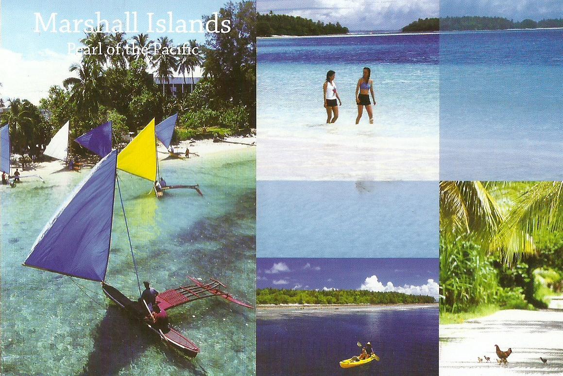
This is a project of collecting postcards from all over the world. Please send me postcards of your beautiful countries, states, islands, regions and subjects of interesting places, so I can feature them here.
Friday, May 17, 2013
Marshall Islands - Pearl Of The Pacific
Iokwe
We welcome you to come visit the Republic of the Marshall islands in Magnificent Micronesia. Experience beauty and nature in its finest form.
Sent by MIVA. Thank you.
The Marshall Islands, officially the Republic of the Marshall Islands (Marshallese: Aolepān Aorōkin M̧ajeļ), is an island country located in the northern Pacific Ocean. Geographically, the country is part of the larger island group of Micronesia, with the population of 68,480 people spread out over 34 low-lying coral atolls, comprising 1,156 individual islands and islets. The islands sharemaritime boundaries with the Federated States of Micronesia to the west, Wake Island to the north, Kiribati to the south-east, and Nauru to the south. The most populous atoll is Majuro, which also acts as the capital.
Micronesian colonists gradually settled the Marshall Islands during the 2nd millennium BC, with inter-island navigation made possible using traditional stick charts. Islands in the archipelago were first explored by Europeans in the 1520s, with Spanish explorer Alonso de Salazar sighting an atoll in August 1526. Other expeditions by Spanish and English ships followed, with the islands' current name stemming from British explorer John Marshall. Recognised as part of the Spanish East Indies in 1874, the islands were sold toGermany in 1884, and became part of German New Guinea in 1885. The Empire of Japan occupied the Marshall Islands in World War I, which were later joined with other former German territories in 1919 by the League of Nations to form the South Pacific Mandate. InWorld War II, the islands were conquered by the United States in the Gilbert and Marshall Islands campaign. Along with other Pacific Islands, the Marshall Islands were then consolidated into the United-States-governed Trust Territory of the Pacific Islands. Self-government was achieved in 1979, and full sovereignty in 1986, under a Compact of Free Association with the United States.
Politically, the Marshall Islands is a presidential republic in free association with the United States, with the US providing defense, funding grants, and access to social services. Having few natural resources, the islands' wealth is based on a service economy, as well as some fishing and agriculture, with a large percentage of the islands' gross domestic product coming from United States aid. The country uses the United States dollar as its currency. The majority of citizens of the Marshall Islands are of Marshallese descent, with small numbers of immigrants from the Philippines and other Pacific islands. The two official languages are Marshallese, a member of the Malayo-Polynesian languages, and English. Almost the entire population of the islands practises some religion, with three-quarters of the country either following the United Church of Christ – Congregational in the Marshall Islands (UCCCMI) or theAssemblies of God. (read further)
Croatia - Krk Island
Multiviews of Krk Island.
Sent by Tomislav, a postcrosser from Zagreb, Croatia.
Krk (pronounced [kr̩̂k]; German: Vegl; Latin: Curicta; Italian: Veglia; Vegliot Dalmatian: Vikla; Ancient greek Kyrikon, Κύρικον) is a Croatian island in the northern Adriatic Sea, located near Rijeka in the Bay of Kvarner and part of the Primorje-Gorski Kotar county.
Krk has for many years been thought the largest Adriatic island, with an area of 405.78 km2 (156.67 sq mi), although recent measurements now give the neighbouring island of Cres an equal surface area. Krk is also the most populous island, with numerous towns and villages totalling 19,286 (2011). (read further)
Germany - Schleswig-Holstein - Kiel
Greetings from City of Kiel
Sent by Christina, a postcrosser from Germany.
Kiel (German pronunciation: [ˈkiːl]) is the capital and most populous city in the northern German state of Schleswig-Holstein, with a population of 242,041 (2011).
Kiel lies approximately 90 kilometres (56 mi) north of Hamburg. Due to its geographic location in the north of Germany, the southeast of the Jutland peninsula, and the southwestern shore of the Baltic Sea, Kiel has become one of the major maritime centres of Germany. For instance, the city is known for a variety of international sailing events, including the annual Kiel Week, which is the biggest sailing event in the world. The Olympic sailing competitions of the 1936 and the 1972 Summer Olympics were held in Kiel.
Kiel has also been one of the traditional homes of the German Navy's Baltic fleet, and continues to be a major high-techshipbuilding centre. Located in Kiel is the Leibniz Institute of Marine Sciences (IFM-GEOMAR) at the University of Kiel. Kiel is an important sea transport hub, thanks to its location at the Kiel Fjord (Kieler Förde) and the busiest artificial waterway in the world,Kiel Canal (Nord-Ostsee-Kanal). A number of passenger ferries to Sweden, Norway, Russia and other countries operate from here. Moreover, today Kiel harbour is an important port of call for cruise ships touring the Baltic Sea.
In 2005 Kiel's GDP per capita was €35,618, well above Germany's national average, and 159% of the European Union's average.
Within Germany and parts of Europe, the city is known for its leading handball team, THW Kiel. The city is home to the University of Kiel (established in 1665). (read further)
Germany - Hamburg/Lower Saxony - Altes Land
Greetings from the Altes Land
Sent by Renee, a postcrosser from Stade, Germany.
Altes Land is an area of reclaimed marshland straddling parts of Lower Saxony and Hamburg. The region is situated downstream from Hamburg on the southwestern riverside of the Elbe around the towns of Stade, Buxtehude, Jork and the Samtgemeinde of Lühe. In Hamburg it includes the quarters of Neuenfelde, Cranz, Francop and Finkenwerder.
The region – the biggest contiguous fruit-producing region in Central Europe – extends over 143 km2 (55 sq mi). 76.8% of the trees areapples, 12.7% are cherries. The areas closest to the Elbe are those with the highest population. They include the most fertile marshlands; towards the Geest the area connects to fens.
The fertile land led to the development of a culture dominated by farming. The villages are known as Marschhufendörfer, a special kind of village where the farmyards are set along a street with the land directly behind them. A characteristic feature is the richly-decorated half-timbered farmhouses with their elaborate gateways. (read further)
Thursday, May 16, 2013
Netherlands - Edam Cheese
Edam Cheese Market
Sent by Marissa, a postcrosser from Leiden, Netherlands.
Edam (Dutch: Edammer) is a semi-hard cheese that originated in the Netherlands, and is named after the town of Edam in the province of North Holland. Edam is traditionally sold in spheres with a pale yellow interior and a coat of red paraffin wax. Edam ages and travels well, and does not spoil; it only hardens. These qualities (among others) made it the world's most popular cheese between the 14th and 18th centuries, both at sea and in remote colonies.
Most "young" Edam cheese sold in stores has a very mild flavor, is slightly salty or nutty, and has almost no smell when compared to other cheeses. As the cheese ages, its flavor sharpens, and it becomes firmer. It has a significantly lower fatcontent than many other traditional cheeses; as little as 28 percent of the cheese is made up of fat. Modern Edam is softer than other cheeses, such as Cheddar, due to its low fat content. However, it is not quite as suitable for toasting as are certain other cheeses, such as Cheddar. (read further)
France - Paris
PARIS AND ITS WONDERS
Place du Tertre and its painters.
The Basilica of Sacré-Cœur.
Sent by Ecole, a group of postcrossers from France.
USA - New Jersey - State Flower
NEW JERSEY'S STATE FLOWER
Common Meadow Violet
(Viola sororia)
With its official status uncertain for over 50 years, the Violet was designated as the state flower in 1971 with strong support from garden clubs across the state. This plant is in bloom from March to June with purple or violet petals.
Sent by Megan, a postcrosser from Missori, USA.
The state flower of New Jersey was originally designated as such by a resolution of the Legislature in 1913. Unfortunately the force of resolution ended with the start of the 1914 legislative session, leaving the violet with uncertain status for the next fifty years. In 1963 an attempt was made to have the Legislature "officially" designate the violet as the state flower, but the legislation apparently failed. In 1971, at the urging of New Jersey's garden clubs, legislation more specifically designating the Common Meadow Violet (Viola sororia) as the state flower was enacted. (Source)
Netherlands - Doetinchem
Multiviews of Doetichem.
Sent by Kirsty, a Swap-Bot partner from Doetinchem, Netherlands.
Doetinchem (Dutch pronunciation: [ˈdu.tɪn.ˌxɛm]; Low Saxon: Deutekem) is a city and municipality in the east of theNetherlands. It is situated along the Oude IJssel (Old IJssel) river in a part of the province of Gelderland called the Achterhoek . The municipality has 56,275 inhabitants (January 1, 2012) and has an area of 79.67 km² (of which 0.57 km² is water). This makes Doetinchem the largest town (by population) in the Achterhoek.
On 1 January 2005, a municipal reorganization merged the neighbouring municipality of Wehl into Doetinchem. (Source)
Tuesday, May 14, 2013
Morocco - Tafraout
Tafraout.
Sent by Omar from Tafraout, Morocco.
Tafraout, also spelled Tafrawt or Tafraoute, is a town in Tiznit Province, Souss-Massa-Drâa, Morocco. It is located in the Anti-Atlas mountains in southern Morocco. According to the 2004 census it has a population of 4,931.
Tiznit is 78 km south of Agadir, well connected by a major road.
The roads to Tafraoute are difficult to traverse - narrow, snakelike, and mountainous. This is a good enough reason to take the Tiznit route.
It takes about an hour to reach Tiznit where a left turning takes you to Tafraoute which is 107 km away. The first forty or so kilometres are plain sailing but once you reach the mountains it becomes more challenging. The road is somewhat narrow though it is still enough for two vehicles to pass without any problems. The climbing road is often unprotected and this is what creates some anxiety and detracts from enjoyment of otherwise stunning scenery. It should take not much longer than two hours to reach Tafraoute including a must stop at the Kerdous Hotel, located on a cliff edge at over three thousand feet above sea level overlooking the magical Kerdous Valley. (Source)
Morocco - Mapcard (3)
Sand dunes of the Sahara, the Atlantic dimensions and the Mediterranean MOROCCO is INFINITE...
Sent by Omar from Tafraout, Morocco.
New Zealand - Mapcard (4)
NEW ZEALAND
Made up of three islands, New Zealand is a country of contrast. With a sub-tropical climate in the north, and snow clad mountains in the south, New Zealand is unique in its beauty and a paradise to visit.
Sent by Lois, a postcrosser from Tauranga, New Zealand.
Subscribe to:
Posts (Atom)